Genouilly geodata
Genouilly (Centre) is a populated place; located in France in Europe/Paris (GMT+2) time zone. With population of 759 people, there are 11065 cities with bigger population in this country. Compared to other cities in France, 53.2% of cities are located further ↑North; 58.4% of cities are located further →East and 51.7% of cities have lower elevation than Genouilly. Note1
Administrative division(s):
- Level 1: Centre
- Level 2: Cher
- Level 3: Arrondissement de Vierzon
- Level 4: Genouilly


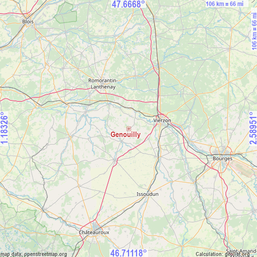
Genouilly GPS coordinates[2]
47° 11' 28.104" North, 1° 53' 10.968" East
| Map corner | latitude | longitude |
|---|---|---|
| Upper-left | 47.6668°, | 1.18326° |
| Center: | 47.19114°, | 1.88638° |
| Lower-right: | 46.71118°, | 2.58951° |
| Map W x H: | 106.3×106.3 km | = 66.1×66.1mi |
| max Lat: | 51.07786° ⇑53.2% North |
| Genouilly: | 47.19114° |
| min Lat: | ⇓46.8% South 41.3874° |
| min Long | Genouilly | max Long |
| -5.08615° | 1.88638° | 9.52242° |
| W 41.6%⇐ | ⇒58.4% E |
Elevation
Elevation of Genouilly is 138 m = 453 ft, and this is 55.7 m = 183 ft below average elevation for this country.
| Max E: |
2333 m = 7654 ft | 48.3% |
| Avg. | 193.7 m = 635 ft | |
| Genouilly | 138 m = 453 ft | |
Min E: |
-1 m = -3 ft | 51.7% |
See also: France elevation on elevation.city.
Geographical zone
Genouilly is located in North temperate zone (between Tropic of Cancer and the Arctic Circle). Distance of this North polar circle is 2154 km =1338.4 mi to North.| Distance of | km | miles | from Genouilly |
|---|---|---|---|
| North Pole | 4759.9 | 2957.7 | to North |
| Arctic Circle | 2154 | 1338.4 | to North |
| Tropic Cancer | 2641.2 | 1641.2 | to South |
| Equator | 5247.2 | 3260.5 | to South |


Nearby cities:
15 places around Genouilly: (largest is in red/bold)
• Châtres-sur-Cher
8.3 km =5.2 mi,  10°
10°
• Graçay
6 km =3.7 mi,  209°
209°
• Langon
11.3 km =7 mi,  336°
336°
• Lury-sur-Arnon
14.7 km =9.1 mi,  118°
118°
• Massay
9.1 km =5.7 mi, 117°
• Mennetou-sur-Cher
8.9 km =5.5 mi,  349°
349°
• Méreau
12.8 km =8 mi,  104°
104°
• Méry-sur-Cher
9.8 km =6.1 mi,  51°
51°
• Saint-Georges-sur-la-Prée
5.4 km =3.4 mi,  43°
43°
• Saint-Hilaire-de-Court
10.2 km =6.3 mi,  80°
80°
• Saint-Julien-sur-Cher
13.2 km =8.2 mi,  320°
320°
• Thénioux
8.1 km =5 mi,  27°
27°
• Vatan
14.2 km =8.8 mi,  203°
203°
• Vierzon
14.2 km =8.8 mi, 76°
• Villefranche-sur-Cher
15.1 km =9.4 mi, 323°
Sources, notices
• [Note1] Compared only with cities in France existing in our database
• [Src1] Map data: © OpenStreetMap contributors (CC-BY-SA)
• [Src2] Other city data from geonames.org with taken over terms of usage.
• [Src3] Geographical zone / Annual Mean Temperature by Robert A. Rohde @ Wikipedia
