Mennetou-sur-Cher geodata
Mennetou-sur-Cher (Centre) is a populated place; located in France in Europe/Paris (GMT+2) time zone. With population of 944 people, there are 9259 cities with bigger population in this country. Compared to other cities in France, 52% of cities are located further ↑North; 58.7% of cities are located further →East and 64% of cities have higher elevation than Mennetou-sur-Cher. Note1
Administrative division(s):
- Level 1: Centre
- Level 2: Département du Loir-et-Cher
- Level 3: Arrondissement de Romorantin-Lanthenay
- Level 4: Mennetou-sur-Cher


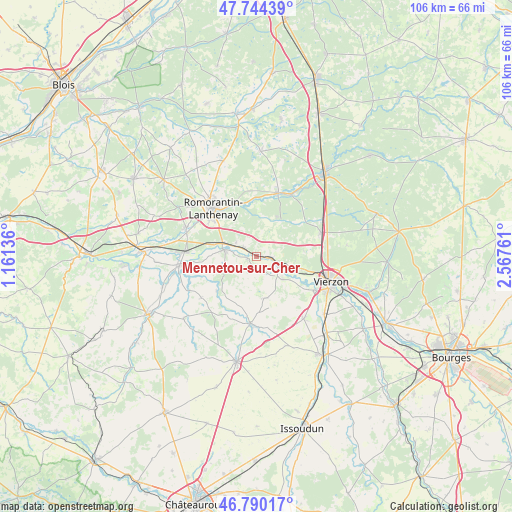
Mennetou-sur-Cher GPS coordinates[2]
47° 16' 9.948" North, 1° 51' 52.164" East
| Map corner | latitude | longitude |
|---|---|---|
| Upper-left | 47.74439°, | 1.16136° |
| Center: | 47.26943°, | 1.86449° |
| Lower-right: | 46.79017°, | 2.56761° |
| Map W x H: | 106.1×106.1 km | = 65.9×65.9mi |
| max Lat: | 51.07786° ⇑52% North |
| Mennetou-sur-Cher: | 47.26943° |
| min Lat: | ⇓48% South 41.3874° |
| min Long | Mennetou-sur-Ch | max Long |
| -5.08615° | 1.86449° | 9.52242° |
| W 41.3%⇐ | ⇒58.7% E |
Elevation
Elevation of Mennetou-sur-Cher is 92 m = 302 ft, and this is 101.7 m = 334 ft below average elevation for this country.
| Max E: |
2333 m = 7654 ft | 64% |
| Avg. | 193.7 m = 635 ft | |
| Mennetou-sur-Cher | 92 m = 302 ft | |
Min E: |
-1 m = -3 ft | 36% |
See also: France elevation on elevation.city.
Geographical zone
Mennetou-sur-Cher is located in North temperate zone (between Tropic of Cancer and the Arctic Circle). Distance of this North polar circle is 2145.3 km =1333 mi to North.| Distance of | km | miles | from Mennetou-sur-Cher |
|---|---|---|---|
| North Pole | 4751.2 | 2952.3 | to North |
| Arctic Circle | 2145.3 | 1333 | to North |
| Tropic Cancer | 2649.9 | 1646.6 | to South |
| Equator | 5255.9 | 3265.9 | to South |


Nearby cities:
15 places around Mennetou-sur-Cher: (largest is in red/bold)
• Châtres-sur-Cher
3.2 km =2 mi,  98°
98°
• Genouilly
8.9 km =5.5 mi,  169°
169°
• Graçay
14 km =8.7 mi,  185°
185°
• La Ferté-Imbault
14.5 km =9 mi,  27°
27°
• Langon
3.3 km =2.1 mi,  299°
299°
• Méry-sur-Cher
9.7 km =6 mi,  105°
105°
• Romorantin-Lanthenay
13.8 km =8.6 mi,  321°
321°
• Saint-Georges-sur-la-Prée
7.2 km =4.5 mi,  131°
131°
• Saint-Hilaire-de-Court
13.7 km =8.5 mi,  121°
121°
• Saint-Julien-sur-Cher
7 km =4.3 mi,  281°
281°
• Selles-Saint-Denis
13.8 km =8.6 mi,  18°
18°
• Theillay
14.2 km =8.8 mi,  69°
69°
• Thénioux
5.6 km =3.5 mi, 105°
• Villefranche-sur-Cher
8.1 km =5 mi,  294°
294°
• Villeherviers
11.9 km =7.4 mi,  335°
335°
Sources, notices
• [Note1] Compared only with cities in France existing in our database
• [Src1] Map data: © OpenStreetMap contributors (CC-BY-SA)
• [Src2] Other city data from geonames.org with taken over terms of usage.
• [Src3] Geographical zone / Annual Mean Temperature by Robert A. Rohde @ Wikipedia
