Cherisy geodata
Cherisy (Centre) is a populated place; located in France in Europe/Paris (GMT+2) time zone. With population of 1,845 people, there are 5138 cities with bigger population in this country. Compared to other cities in France, 74.3% of cities are located further ↓South; 63.9% of cities are located further →East and 50.9% of cities have higher elevation than Cherisy. Note1
Administrative division(s):
- Level 1: Centre
- Level 2: Département d'Eure-et-Loir
- Level 3: Arrondissement de Dreux
- Level 4: Cherisy


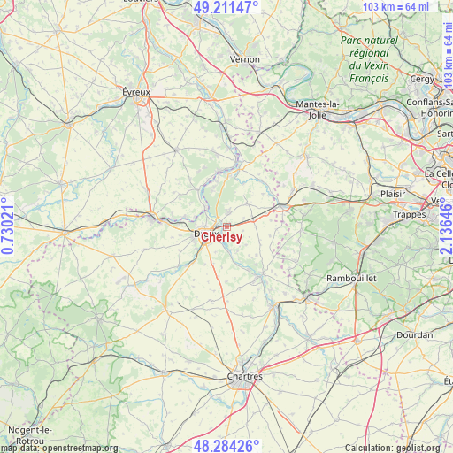
Cherisy GPS coordinates[2]
48° 45' 0" North, 1° 25' 59.988" East
| Map corner | latitude | longitude |
|---|---|---|
| Upper-left | 49.21147°, | 0.73021° |
| Center: | 48.75°, | 1.43333° |
| Lower-right: | 48.28426°, | 2.13646° |
| Map W x H: | 103.1×103.1 km | = 64.1×64.1mi |
| max Lat: | 51.07786° ⇑25.7% North |
| Cherisy: | 48.75° |
| min Lat: | ⇓74.3% South 41.3874° |
| min Long | Cherisy | max Long |
| -5.08615° | 1.43333° | 9.52242° |
| W 36.1%⇐ | ⇒63.9% E |
Elevation
Elevation of Cherisy is 129 m = 423 ft, and this is 64.7 m = 212 ft below average elevation for this country.
| Max E: |
2333 m = 7654 ft | 50.9% |
| Avg. | 193.7 m = 635 ft | |
| Cherisy | 129 m = 423 ft | |
Min E: |
-1 m = -3 ft | 49.1% |
See also: France elevation on elevation.city.
Geographical zone
Cherisy is located in North temperate zone (between Tropic of Cancer and the Arctic Circle). Distance of this North polar circle is 1980.7 km =1230.7 mi to North.| Distance of | km | miles | from Cherisy |
|---|---|---|---|
| North Pole | 4586.6 | 2850 | to North |
| Arctic Circle | 1980.7 | 1230.7 | to North |
| Tropic Cancer | 2814.6 | 1748.9 | to South |
| Equator | 5420.5 | 3368.1 | to South |


Nearby cities:
15 places around Cherisy: (largest is in red/bold)
• Abondant
4 km =2.5 mi,  7°
7°
• Broué
6.6 km =4.1 mi,  91°
91°
• Bû
7 km =4.3 mi,  41°
41°
• Charpont
5.7 km =3.5 mi,  177°
177°
• Dreux
5.2 km =3.2 mi,  253°
253°
• Garnay
8.7 km =5.4 mi,  234°
234°
• Luray
4.2 km =2.6 mi,  217°
217°
• Montreuil
5.6 km =3.5 mi,  303°
303°
• Muzy
6.8 km =4.2 mi,  293°
293°
• Mézières-en-Drouais
3 km =1.9 mi,  192°
192°
• Ouerre
6 km =3.7 mi,  156°
156°
• Saint-Georges-Motel
6.9 km =4.3 mi,  314°
314°
• Sainte-Gemme-Moronval
1.9 km =1.2 mi, 227°
• Vernouillet
5.7 km =3.5 mi,  235°
235°
• Villemeux-sur-Eure
8.9 km =5.5 mi,  165°
165°
Sources, notices
• [Note1] Compared only with cities in France existing in our database
• [Src1] Map data: © OpenStreetMap contributors (CC-BY-SA)
• [Src2] Other city data from geonames.org with taken over terms of usage.
• [Src3] Geographical zone / Annual Mean Temperature by Robert A. Rohde @ Wikipedia
