La Chapelle-Heulin geodata
La Chapelle-Heulin (Pays de la Loire) is a populated place; located in France in Europe/Paris (GMT+2) time zone. With population of 1,997 people, there are 4795 cities with bigger population in this country. Compared to other cities in France, 53.3% of cities are located further ↑North; 91.1% of cities are located further →East and 95.7% of cities have higher elevation than La Chapelle-Heulin. Note1
Administrative division(s):
- Level 1: Pays de la Loire
- Level 2: Loire-Atlantique
- Level 3: Arrondissement de Nantes
- Level 4: La Chapelle-Heulin


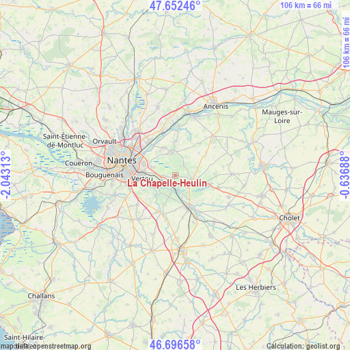
La Chapelle-Heulin GPS coordinates[2]
47° 10' 36.012" North, 1° 20' 24" West
| Map corner | latitude | longitude |
|---|---|---|
| Upper-left | 47.65246°, | -2.04313° |
| Center: | 47.17667°, | -1.34° |
| Lower-right: | 46.69658°, | -0.63688° |
| Map W x H: | 106.3×106.3 km | = 66.1×66.1mi |
| max Lat: | 51.07786° ⇑53.3% North |
| La Chapelle-Heulin: | 47.17667° |
| min Lat: | ⇓46.7% South 41.3874° |
| min Long | La Chapelle-Heu | max Long |
| -5.08615° | -1.34° | 9.52242° |
| W 8.9%⇐ | ⇒91.1% E |
Elevation
Elevation of La Chapelle-Heulin is 15 m = 49 ft, and this is 178.7 m = 586 ft below average elevation for this country.
| Max E: |
2333 m = 7654 ft | 95.7% |
| Avg. | 193.7 m = 635 ft | |
| La Chapelle-Heulin | 15 m = 49 ft | |
Min E: |
-1 m = -3 ft | 4.3% |
See also: France elevation on elevation.city.
Geographical zone
La Chapelle-Heulin is located in North temperate zone (between Tropic of Cancer and the Arctic Circle). Distance of this North polar circle is 2155.6 km =1339.4 mi to North.| Distance of | km | miles | from La Chapelle-Heulin |
|---|---|---|---|
| North Pole | 4761.5 | 2958.7 | to North |
| Arctic Circle | 2155.6 | 1339.4 | to North |
| Tropic Cancer | 2639.6 | 1640.2 | to South |
| Equator | 5245.6 | 3259.5 | to South |


Nearby cities:
15 places around La Chapelle-Heulin: (largest is in red/bold)
• Gorges
9.1 km =5.7 mi,  160°
160°
• Haute-Goulaine
7.2 km =4.5 mi,  290°
290°
• La Haie-Fouassière
5 km =3.1 mi,  241°
241°
• La Remaudière
9.9 km =6.2 mi,  47°
47°
• Le Landreau
4.1 km =2.5 mi,  40°
40°
• Le Loroux-Bottereau
6.8 km =4.2 mi,  353°
353°
• Le Pallet
4.3 km =2.7 mi,  174°
174°
• Maisdon-sur-Sèvre
9.3 km =5.8 mi,  198°
198°
• Monnières
5 km =3.1 mi,  191°
191°
• Mouzillon
5.9 km =3.7 mi,  132°
132°
• Saint-Fiacre-sur-Maine
7 km =4.3 mi, 236°
• Saint-Julien-de-Concelles
9.1 km =5.7 mi,  338°
338°
• Saint-Lumine-de-Clisson
10.3 km =6.4 mi,  177°
177°
• Vallet
5.8 km =3.6 mi,  105°
105°
• Vertou
9.8 km =6.1 mi,  264°
264°
Sources, notices
• [Note1] Compared only with cities in France existing in our database
• [Src1] Map data: © OpenStreetMap contributors (CC-BY-SA)
• [Src2] Other city data from geonames.org with taken over terms of usage.
• [Src3] Geographical zone / Annual Mean Temperature by Robert A. Rohde @ Wikipedia
