Chérac geodata
Chérac (Nouvelle-Aquitaine) is a populated place; located in France in Europe/Paris (GMT+2) time zone. With population of 1,094 people, there are 8167 cities with bigger population in this country. Compared to other cities in France, 70.8% of cities are located further ↑North; 82.6% of cities are located further →East and 77.8% of cities have higher elevation than Chérac. Note1
Administrative division(s):
- Level 1: Nouvelle-Aquitaine
- Level 2: Charente-Maritime
- Level 3: Arrondissement de Saintes
- Level 4: Chérac


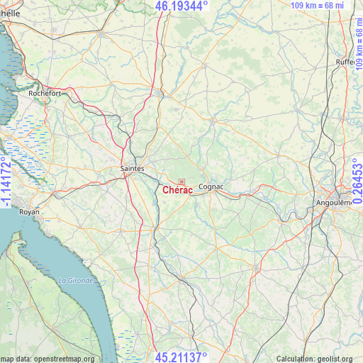
Chérac GPS coordinates[2]
45° 42' 16.416" North, 0° 26' 18.924" West
| Map corner | latitude | longitude |
|---|---|---|
| Upper-left | 46.19344°, | -1.14172° |
| Center: | 45.70456°, | -0.43859° |
| Lower-right: | 45.21137°, | 0.26453° |
| Map W x H: | 109.2×109.2 km | = 67.9×67.9mi |
| max Lat: | 51.07786° ⇑70.8% North |
| Chérac: | 45.70456° |
| min Lat: | ⇓29.2% South 41.3874° |
| min Long | Chérac | max Long |
| -5.08615° | -0.43859° | 9.52242° |
| W 17.4%⇐ | ⇒82.6% E |
Elevation
Elevation of Chérac is 60 m = 197 ft, and this is 133.7 m = 439 ft below average elevation for this country.
| Max E: |
2333 m = 7654 ft | 77.8% |
| Avg. | 193.7 m = 635 ft | |
| Chérac | 60 m = 197 ft | |
Min E: |
-1 m = -3 ft | 22.2% |
See also: France elevation on elevation.city.
Geographical zone
Chérac is located in North temperate zone (between Tropic of Cancer and the Arctic Circle). Distance of this North polar circle is 2319.3 km =1441.1 mi to North.| Distance of | km | miles | from Chérac |
|---|---|---|---|
| North Pole | 4925.2 | 3060.4 | to North |
| Arctic Circle | 2319.3 | 1441.1 | to North |
| Tropic Cancer | 2476 | 1538.5 | to South |
| Equator | 5081.9 | 3157.7 | to South |


Nearby cities:
15 places around Chérac: (largest is in red/bold)
• Ars
8.1 km =5 mi,  147°
147°
• Burie
7.7 km =4.8 mi,  9°
9°
• Cherves-Richemont
8.1 km =5 mi,  57°
57°
• Châteaubernard
9.2 km =5.7 mi,  117°
117°
• Cognac
8.6 km =5.3 mi,  96°
96°
• Gimeux
9.4 km =5.8 mi,  144°
144°
• Javrezac
6.9 km =4.3 mi,  94°
94°
• Merpins
3.8 km =2.4 mi,  128°
128°
• Montils
8 km =5 mi,  218°
218°
• Pérignac
9.3 km =5.8 mi,  192°
192°
• Saint-Laurent-de-Cognac
2.5 km =1.6 mi,  110°
110°
• Saint-Sauvant
6.4 km =4 mi,  306°
306°
• Saint-Sever-de-Saintonge
4.8 km =3 mi,  263°
263°
• Saint-Sulpice-de-Cognac
7.6 km =4.7 mi,  36°
36°
• Salignac-sur-Charente
3.7 km =2.3 mi,  168°
168°
Sources, notices
• [Note1] Compared only with cities in France existing in our database
• [Src1] Map data: © OpenStreetMap contributors (CC-BY-SA)
• [Src2] Other city data from geonames.org with taken over terms of usage.
• [Src3] Geographical zone / Annual Mean Temperature by Robert A. Rohde @ Wikipedia
