Gilly-lès-Cîteaux geodata
Gilly-lès-Cîteaux (Bourgogne-Franche-Comté) is a populated place; located in France in Europe/Paris (GMT+2) time zone. With population of 586 people, there are 13542 cities with bigger population in this country. Compared to other cities in France, 53.5% of cities are located further ↑North; 77.5% of cities are located further ←West and 70.1% of cities have lower elevation than Gilly-lès-Cîteaux. Note1
Administrative division(s):
- Level 1: Bourgogne-Franche-Comté
- Level 2: Département de la Côte-d'Or
- Level 3: Arrondissement de Beaune
- Level 4: Gilly-lès-Cîteaux


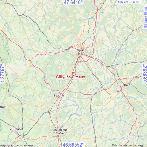
Gilly-lès-Cîteaux GPS coordinates[2]
47° 9' 56.556" North, 4° 58' 50.844" East
| Map corner | latitude | longitude |
|---|---|---|
| Upper-left | 47.6416°, | 4.27767° |
| Center: | 47.16571°, | 4.98079° |
| Lower-right: | 46.68552°, | 5.68392° |
| Map W x H: | 106.3×106.3 km | = 66.1×66.1mi |
| max Lat: | 51.07786° ⇑53.5% North |
| Gilly-lès-Cîteaux: | 47.16571° |
| min Lat: | ⇓46.5% South 41.3874° |
| min Long | Gilly-lès-Cît | max Long |
| -5.08615° | 4.98079° | 9.52242° |
| W 77.5%⇐ | ⇒22.5% E |
Elevation
Elevation of Gilly-lès-Cîteaux is 220 m = 722 ft, and this is 26.3 m = 86 ft above average elevation for this country.
| Max E: |
2333 m = 7654 ft | 29.9% |
| Gilly-lès-Cîteaux | 220 m 722 ft | |
| Avg. | 193.7 m = 635 ft | |
Min E: |
-1 m = -3 ft | 70.1% |
See also: France elevation on elevation.city.
Geographical zone
Gilly-lès-Cîteaux is located in North temperate zone (between Tropic of Cancer and the Arctic Circle). Distance of this North polar circle is 2156.8 km =1340.2 mi to North.| Distance of | km | miles | from Gilly-lès-Cîteaux |
|---|---|---|---|
| North Pole | 4762.7 | 2959.4 | to North |
| Arctic Circle | 2156.8 | 1340.2 | to North |
| Tropic Cancer | 2638.4 | 1639.4 | to South |
| Equator | 5244.3 | 3258.7 | to South |


Nearby cities:
15 places around Gilly-lès-Cîteaux: (largest is in red/bold)
• Brochon
8.1 km =5 mi,  353°
353°
• Comblanchien
8.4 km =5.2 mi,  212°
212°
• Corcelles-lès-Cîteaux
7.6 km =4.7 mi,  85°
85°
• Corgoloin
10.4 km =6.5 mi, 209°
• Couchey
10.5 km =6.5 mi,  0°
0°
• Fixin
8.8 km =5.5 mi,  356°
356°
• Flagey-Echézeaux
0.2 km =0.1 mi,  60°
60°
• Fénay
9.6 km =6 mi,  39°
39°
• Gevrey-Chambertin
6.8 km =4.2 mi, 351°
• Morey-Saint-Denis
3.7 km =2.3 mi,  338°
338°
• Noiron-sous-Gevrey
8.1 km =5 mi,  66°
66°
• Nuits-Saint-Georges
4 km =2.5 mi,  216°
216°
• Perrigny-lès-Dijon
11.4 km =7.1 mi,  9°
9°
• Saulon-la-Chapelle
9.8 km =6.1 mi, 56°
• Saulon-la-Rue
8.8 km =5.5 mi,  45°
45°
Sources, notices
• [Note1] Compared only with cities in France existing in our database
• [Src1] Map data: © OpenStreetMap contributors (CC-BY-SA)
• [Src2] Other city data from geonames.org with taken over terms of usage.
• [Src3] Geographical zone / Annual Mean Temperature by Robert A. Rohde @ Wikipedia
