Génis geodata
Génis (Nouvelle-Aquitaine) is a populated place; located in France in Europe/Paris (GMT+2) time zone. With population of 526 people, there are 14691 cities with bigger population in this country. Compared to other cities in France, 76.1% of cities are located further ↑North; 67.2% of cities are located further →East and 77.9% of cities have lower elevation than Génis. Note1
Administrative division(s):
- Level 1: Nouvelle-Aquitaine
- Level 2: Dordogne
- Level 3: Arrondissement de Nontron
- Level 4: Génis


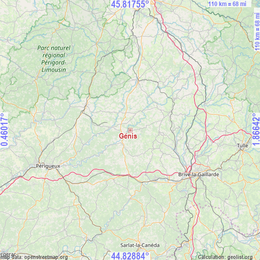
Génis GPS coordinates[2]
45° 19' 31.26" North, 1° 9' 47.88" East
| Map corner | latitude | longitude |
|---|---|---|
| Upper-left | 45.81755°, | 0.46017° |
| Center: | 45.32535°, | 1.1633° |
| Lower-right: | 44.82884°, | 1.86642° |
| Map W x H: | 109.9×109.9 km | = 68.3×68.3mi |
| max Lat: | 51.07786° ⇑76.1% North |
| Génis: | 45.32535° |
| min Lat: | ⇓23.9% South 41.3874° |
| min Long | Génis | max Long |
| -5.08615° | 1.1633° | 9.52242° |
| W 32.8%⇐ | ⇒67.2% E |
Elevation
Elevation of Génis is 271 m = 889 ft, and this is 77.3 m = 254 ft above average elevation for this country.
| Max E: |
2333 m = 7654 ft | 22.1% |
| Génis | 271 m 889 ft | |
| Avg. | 193.7 m = 635 ft | |
Min E: |
-1 m = -3 ft | 77.9% |
See also: France elevation on elevation.city.
Geographical zone
Génis is located in North temperate zone (between Tropic of Cancer and the Arctic Circle). Distance of this North polar circle is 2361.5 km =1467.4 mi to North.| Distance of | km | miles | from Génis |
|---|---|---|---|
| North Pole | 4967.4 | 3086.6 | to North |
| Arctic Circle | 2361.5 | 1467.4 | to North |
| Tropic Cancer | 2433.8 | 1512.3 | to South |
| Equator | 5039.7 | 3131.5 | to South |


Nearby cities:
15 places around Génis: (largest is in red/bold)
• Angoisse
11.5 km =7.1 mi,  349°
349°
• Ayen
15.5 km =9.6 mi,  124°
124°
• Cherveix-Cubas
5.4 km =3.4 mi,  223°
223°
• Coulaures
14.5 km =9 mi,  261°
261°
• Excideuil
9.1 km =5.7 mi,  277°
277°
• Glandon
17.8 km =11.1 mi,  15°
15°
• Hautefort
7.4 km =4.6 mi,  188°
188°
• Juillac
12.5 km =7.8 mi,  93°
93°
• Lanouaille
8 km =5 mi, 346°
• Payzac
9.3 km =5.8 mi,  26°
26°
• Saint-Rabier
17.1 km =10.6 mi,  183°
183°
• Salagnac
3.1 km =1.9 mi, 120°
• Savignac-Lédrier
6.2 km =3.9 mi,  46°
46°
• Tourtoirac
10.2 km =6.3 mi,  233°
233°
• Vignols
17.7 km =11 mi, 91°
Sources, notices
• [Note1] Compared only with cities in France existing in our database
• [Src1] Map data: © OpenStreetMap contributors (CC-BY-SA)
• [Src2] Other city data from geonames.org with taken over terms of usage.
• [Src3] Geographical zone / Annual Mean Temperature by Robert A. Rohde @ Wikipedia
