Glandon geodata
Glandon (Nouvelle-Aquitaine) is a seat of a fourth-order administrative division; located in France in Europe/Paris (GMT+2) time zone. With population of 801 people, there are 10598 cities with bigger population in this country. Compared to other cities in France, 74.3% of cities are located further ↑North; 66.4% of cities are located further →East and 87.3% of cities have lower elevation than Glandon. Note1
Administrative division(s):
- Level 1: Nouvelle-Aquitaine
- Level 2: Haute-Vienne
- Level 3: Arrondissement de Limoges
- Level 4: Glandon


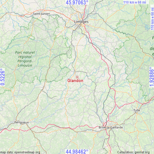
Glandon GPS coordinates[2]
45° 28' 47.208" North, 1° 13' 32.628" East
| Map corner | latitude | longitude |
|---|---|---|
| Upper-left | 45.97063°, | 0.5226° |
| Center: | 45.47978°, | 1.22573° |
| Lower-right: | 44.98462°, | 1.92886° |
| Map W x H: | 109.6×109.6 km | = 68.1×68.1mi |
| max Lat: | 51.07786° ⇑74.3% North |
| Glandon: | 45.47978° |
| min Lat: | ⇓25.7% South 41.3874° |
| min Long | Glandon | max Long |
| -5.08615° | 1.22573° | 9.52242° |
| W 33.6%⇐ | ⇒66.4% E |
Elevation
Elevation of Glandon is 378 m = 1240 ft, and this is 184.3 m = 605 ft above average elevation for this country.
| Max E: |
2333 m = 7654 ft | 12.7% |
| Glandon | 378 m 1240 ft | |
| Avg. | 193.7 m = 635 ft | |
Min E: |
-1 m = -3 ft | 87.3% |
See also: France elevation on elevation.city.
Geographical zone
Glandon is located in North temperate zone (between Tropic of Cancer and the Arctic Circle). Distance of this North polar circle is 2344.3 km =1456.7 mi to North.| Distance of | km | miles | from Glandon |
|---|---|---|---|
| North Pole | 4950.2 | 3075.9 | to North |
| Arctic Circle | 2344.3 | 1456.7 | to North |
| Tropic Cancer | 2451 | 1523 | to South |
| Equator | 5056.9 | 3142.2 | to South |


Nearby cities:
15 places around Glandon: (largest is in red/bold)
• Angoisse
9 km =5.6 mi,  229°
229°
• Arnac-Pompadour
13.7 km =8.5 mi,  124°
124°
• Château-Chervix
17.3 km =10.7 mi,  35°
35°
• Coussac-Bonneval
8.4 km =5.2 mi,  65°
65°
• Génis
17.8 km =11.1 mi,  195°
195°
• Jumilhac-le-Grand
12.8 km =8 mi,  277°
277°
• La Meyze
15.3 km =9.5 mi,  356°
356°
• Ladignac-le-Long
14.4 km =8.9 mi,  322°
322°
• Lanouaille
11.6 km =7.2 mi,  215°
215°
• Lubersac
14.5 km =9 mi,  105°
105°
• Payzac
8.9 km =5.5 mi,  184°
184°
• Saint-Paul-la-Roche
17.7 km =11 mi,  269°
269°
• Saint-Sornin-Lavolps
16.7 km =10.4 mi,  132°
132°
• Saint-Yrieix-la-Perche
4.2 km =2.6 mi,  335°
335°
• Savignac-Lédrier
12.9 km =8 mi, 181°
Sources, notices
• [Note1] Compared only with cities in France existing in our database
• [Src1] Map data: © OpenStreetMap contributors (CC-BY-SA)
• [Src2] Other city data from geonames.org with taken over terms of usage.
• [Src3] Geographical zone / Annual Mean Temperature by Robert A. Rohde @ Wikipedia
