Genac geodata
Genac (Nouvelle-Aquitaine) is a populated place; located in France in Europe/Paris (GMT+2) time zone. With population of 706 people, there are 11718 cities with bigger population in this country. Compared to other cities in France, 69.3% of cities are located further ↑North; 77.9% of cities are located further →East and 75.8% of cities have higher elevation than Genac. Note1
Administrative division(s):
- Level 1: Nouvelle-Aquitaine
- Level 2: Charente
- Level 3: Arrondissement de Cognac
- Level 4: Genac-Bignac


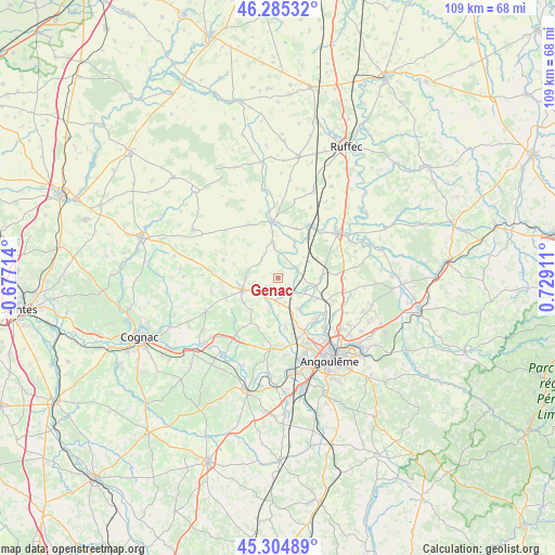
Genac GPS coordinates[2]
45° 47' 50.136" North, 0° 1' 33.528" East
| Map corner | latitude | longitude |
|---|---|---|
| Upper-left | 46.28532°, | -0.67714° |
| Center: | 45.79726°, | 0.02598° |
| Lower-right: | 45.30489°, | 0.72911° |
| Map W x H: | 109×109 km | = 67.7×67.7mi |
| max Lat: | 51.07786° ⇑69.3% North |
| Genac: | 45.79726° |
| min Lat: | ⇓30.7% South 41.3874° |
| min Long | Genac | max Long |
| -5.08615° | 0.02598° | 9.52242° |
| W 22.1%⇐ | ⇒77.9% E |
Elevation
Elevation of Genac is 65 m = 213 ft, and this is 128.7 m = 422 ft below average elevation for this country.
| Max E: |
2333 m = 7654 ft | 75.8% |
| Avg. | 193.7 m = 635 ft | |
| Genac | 65 m = 213 ft | |
Min E: |
-1 m = -3 ft | 24.2% |
See also: France elevation on elevation.city.
Geographical zone
Genac is located in North temperate zone (between Tropic of Cancer and the Arctic Circle). Distance of this North polar circle is 2309 km =1434.7 mi to North.| Distance of | km | miles | from Genac |
|---|---|---|---|
| North Pole | 4914.9 | 3054 | to North |
| Arctic Circle | 2309 | 1434.7 | to North |
| Tropic Cancer | 2486.3 | 1544.9 | to South |
| Equator | 5092.2 | 3164.1 | to South |


Nearby cities:
15 places around Genac: (largest is in red/bold)
• Aigre
10.8 km =6.7 mi,  353°
353°
• Asnières-sur-Nouère
9.2 km =5.7 mi,  168°
168°
• Gourville
4.8 km =3 mi,  318°
318°
• Luxé
12.8 km =8 mi,  33°
33°
• Marcillac-Lanville
5.4 km =3.4 mi,  355°
355°
• Marsac
7.3 km =4.5 mi,  147°
147°
• Montignac-Charente
7.8 km =4.8 mi,  101°
101°
• Rouillac
7.4 km =4.6 mi,  251°
251°
• Saint-Amant-de-Boixe
8.5 km =5.3 mi,  89°
89°
• Saint-Cybardeaux
5.3 km =3.3 mi,  232°
232°
• Saint-Genis-d’Hiersac
5.3 km =3.3 mi,  177°
177°
• Tourriers
12.8 km =8 mi, 90°
• Vars
8.6 km =5.3 mi,  116°
116°
• Villejésus
10.9 km =6.8 mi,  1°
1°
• Vindelle
11.4 km =7.1 mi,  141°
141°
Sources, notices
• [Note1] Compared only with cities in France existing in our database
• [Src1] Map data: © OpenStreetMap contributors (CC-BY-SA)
• [Src2] Other city data from geonames.org with taken over terms of usage.
• [Src3] Geographical zone / Annual Mean Temperature by Robert A. Rohde @ Wikipedia
