Tourriers geodata
Tourriers (Nouvelle-Aquitaine) is a populated place; located in France in Europe/Paris (GMT+2) time zone. With population of 608 people, there are 13192 cities with bigger population in this country. Compared to other cities in France, 69.3% of cities are located further ↑North; 76.3% of cities are located further →East and 56.9% of cities have higher elevation than Tourriers. Note1
Administrative division(s):
- Level 1: Nouvelle-Aquitaine
- Level 2: Charente
- Level 3: Arrondissement de Confolens
- Level 4: Tourriers


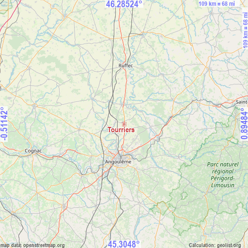
Tourriers GPS coordinates[2]
45° 47' 49.848" North, 0° 11' 30.156" East
| Map corner | latitude | longitude |
|---|---|---|
| Upper-left | 46.28524°, | -0.51142° |
| Center: | 45.79718°, | 0.19171° |
| Lower-right: | 45.3048°, | 0.89484° |
| Map W x H: | 109×109 km | = 67.7×67.7mi |
| max Lat: | 51.07786° ⇑69.3% North |
| Tourriers: | 45.79718° |
| min Lat: | ⇓30.7% South 41.3874° |
| min Long | Tourriers | max Long |
| -5.08615° | 0.19171° | 9.52242° |
| W 23.7%⇐ | ⇒76.3% E |
Elevation
Elevation of Tourriers is 111 m = 364 ft, and this is 82.7 m = 271 ft below average elevation for this country.
| Max E: |
2333 m = 7654 ft | 56.9% |
| Avg. | 193.7 m = 635 ft | |
| Tourriers | 111 m = 364 ft | |
Min E: |
-1 m = -3 ft | 43.1% |
See also: France elevation on elevation.city.
Geographical zone
Tourriers is located in North temperate zone (between Tropic of Cancer and the Arctic Circle). Distance of this North polar circle is 2309 km =1434.7 mi to North.| Distance of | km | miles | from Tourriers |
|---|---|---|---|
| North Pole | 4914.9 | 3054 | to North |
| Arctic Circle | 2309 | 1434.7 | to North |
| Tropic Cancer | 2486.3 | 1544.9 | to South |
| Equator | 5092.2 | 3164.1 | to South |


Nearby cities:
15 places around Tourriers: (largest is in red/bold)
• Agris
11.4 km =7.1 mi,  102°
102°
• Anais
2.9 km =1.8 mi,  152°
152°
• Balzac
12.3 km =7.6 mi,  208°
208°
• Brie
7.6 km =4.7 mi, 149°
• Champniers
9.2 km =5.7 mi,  173°
173°
• Jauldes
5.3 km =3.3 mi, 104°
• La Rochette
9.5 km =5.9 mi,  87°
87°
• Luxé
12.2 km =7.6 mi,  331°
331°
• Mansle
8.7 km =5.4 mi,  353°
353°
• Marsac
10.8 km =6.7 mi,  235°
235°
• Montignac-Charente
5.5 km =3.4 mi,  253°
253°
• Saint-Amant-de-Boixe
4.4 km =2.7 mi,  271°
271°
• Saint-Angeau
9.3 km =5.8 mi,  52°
52°
• Vars
6.5 km =4 mi,  233°
233°
• Vindelle
10.7 km =6.6 mi, 213°
Sources, notices
• [Note1] Compared only with cities in France existing in our database
• [Src1] Map data: © OpenStreetMap contributors (CC-BY-SA)
• [Src2] Other city data from geonames.org with taken over terms of usage.
• [Src3] Geographical zone / Annual Mean Temperature by Robert A. Rohde @ Wikipedia
