Villejésus geodata
Villejésus (Nouvelle-Aquitaine) is a populated place; located in France in Europe/Paris (GMT+2) time zone. With population of 568 people, there are 13863 cities with bigger population in this country. Compared to other cities in France, 67.7% of cities are located further ↑North; 77.9% of cities are located further →East and 71.9% of cities have higher elevation than Villejésus. Note1
Administrative division(s):
- Level 1: Nouvelle-Aquitaine
- Level 2: Charente
- Level 3: Arrondissement de Confolens
- Level 4: Aigre


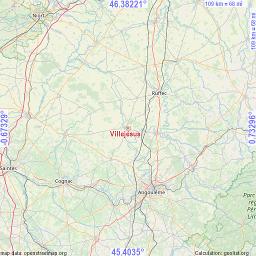
Villejésus GPS coordinates[2]
45° 53' 42.036" North, 0° 1' 47.424" East
| Map corner | latitude | longitude |
|---|---|---|
| Upper-left | 46.38221°, | -0.67329° |
| Center: | 45.89501°, | 0.02984° |
| Lower-right: | 45.4035°, | 0.73296° |
| Map W x H: | 108.8×108.8 km | = 67.6×67.6mi |
| max Lat: | 51.07786° ⇑67.7% North |
| Villejésus: | 45.89501° |
| min Lat: | ⇓32.3% South 41.3874° |
| min Long | Villejésus | max Long |
| -5.08615° | 0.02984° | 9.52242° |
| W 22.1%⇐ | ⇒77.9% E |
Elevation
Elevation of Villejésus is 74 m = 243 ft, and this is 119.7 m = 393 ft below average elevation for this country.
| Max E: |
2333 m = 7654 ft | 71.9% |
| Avg. | 193.7 m = 635 ft | |
| Villejésus | 74 m = 243 ft | |
Min E: |
-1 m = -3 ft | 28.1% |
See also: France elevation on elevation.city.
Geographical zone
Villejésus is located in North temperate zone (between Tropic of Cancer and the Arctic Circle). Distance of this North polar circle is 2298.1 km =1428 mi to North.| Distance of | km | miles | from Villejésus |
|---|---|---|---|
| North Pole | 4904 | 3047.2 | to North |
| Arctic Circle | 2298.1 | 1428 | to North |
| Tropic Cancer | 2497.1 | 1551.6 | to South |
| Equator | 5103 | 3170.9 | to South |


Nearby cities:
15 places around Villejésus: (largest is in red/bold)
• Aigre
1.6 km =1 mi,  264°
264°
• Genac
10.9 km =6.8 mi,  181°
181°
• Gourville
8 km =5 mi,  205°
205°
• La Faye
16.6 km =10.3 mi,  32°
32°
• Luxé
6.7 km =4.2 mi,  91°
91°
• Mansle
11.8 km =7.3 mi,  100°
100°
• Marcillac-Lanville
5.5 km =3.4 mi,  186°
186°
• Montignac-Charente
14.4 km =8.9 mi,  149°
149°
• Rouillac
15.1 km =9.4 mi, 208°
• Saint-Amant-de-Boixe
13.5 km =8.4 mi,  142°
142°
• Saint-Cybardeaux
14.8 km =9.2 mi,  197°
197°
• Saint-Genis-d’Hiersac
16.1 km =10 mi, 180°
• Tourriers
16.6 km =10.3 mi,  130°
130°
• Vars
16.5 km =10.3 mi, 153°
• Villefagnan
13.5 km =8.4 mi,  16°
16°
Sources, notices
• [Note1] Compared only with cities in France existing in our database
• [Src1] Map data: © OpenStreetMap contributors (CC-BY-SA)
• [Src2] Other city data from geonames.org with taken over terms of usage.
• [Src3] Geographical zone / Annual Mean Temperature by Robert A. Rohde @ Wikipedia
