Gauciel geodata
Gauciel (Normandy) is a populated place; located in France in Europe/Paris (GMT+2) time zone. With population of 885 people, there are 9782 cities with bigger population in this country. Compared to other cities in France, 80.4% of cities are located further ↓South; 66.2% of cities are located further →East and 52.5% of cities have lower elevation than Gauciel. Note1
Administrative division(s):
- Level 1: Normandy
- Level 2: Département de l'Eure
- Level 3: Arrondissement d’Évreux
- Level 4: Gauciel


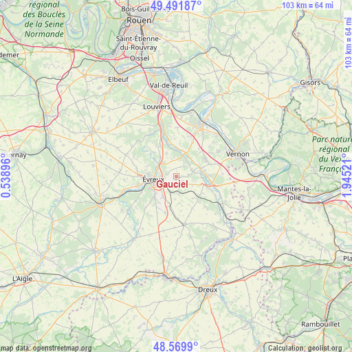
Gauciel GPS coordinates[2]
49° 1' 58.872" North, 1° 14' 31.524" East
| Map corner | latitude | longitude |
|---|---|---|
| Upper-left | 49.49187°, | 0.53896° |
| Center: | 49.03302°, | 1.24209° |
| Lower-right: | 48.5699°, | 1.94521° |
| Map W x H: | 102.5×102.5 km | = 63.7×63.7mi |
| max Lat: | 51.07786° ⇑19.6% North |
| Gauciel: | 49.03302° |
| min Lat: | ⇓80.4% South 41.3874° |
| min Long | Gauciel | max Long |
| -5.08615° | 1.24209° | 9.52242° |
| W 33.8%⇐ | ⇒66.2% E |
Elevation
Elevation of Gauciel is 141 m = 463 ft, and this is 52.7 m = 173 ft below average elevation for this country.
| Max E: |
2333 m = 7654 ft | 47.5% |
| Avg. | 193.7 m = 635 ft | |
| Gauciel | 141 m = 463 ft | |
Min E: |
-1 m = -3 ft | 52.5% |
See also: France elevation on elevation.city.
Geographical zone
Gauciel is located in North temperate zone (between Tropic of Cancer and the Arctic Circle). Distance of this North polar circle is 1949.2 km =1211.2 mi to North.| Distance of | km | miles | from Gauciel |
|---|---|---|---|
| North Pole | 4555.1 | 2830.4 | to North |
| Arctic Circle | 1949.2 | 1211.2 | to North |
| Tropic Cancer | 2846 | 1768.4 | to South |
| Equator | 5452 | 3387.7 | to South |


Nearby cities:
15 places around Gauciel: (largest is in red/bold)
• Autheuil-Authouillet
8 km =5 mi,  21°
21°
• Cierrey
3.9 km =2.4 mi,  139°
139°
• Fontaine-sous-Jouy
5.2 km =3.2 mi,  44°
44°
• Gravigny
5.7 km =3.5 mi,  292°
292°
• Guichainville
5 km =3.1 mi,  225°
225°
• Huest
2.7 km =1.7 mi,  283°
283°
• Jouy-sur-Eure
4.8 km =3 mi,  64°
64°
• Le Boulay-Morin
7 km =4.3 mi,  322°
322°
• Le Val-David
5.6 km =3.5 mi,  174°
174°
• Le Vieil-Évreux
3.2 km =2 mi,  185°
185°
• Miserey
2.4 km =1.5 mi,  122°
122°
• Normanville
7.9 km =4.9 mi,  310°
310°
• Reuilly
5.1 km =3.2 mi,  345°
345°
• Écardenville-sur-Eure
7.9 km =4.9 mi,  14°
14°
• Évreux
6.7 km =4.2 mi,  261°
261°
Sources, notices
• [Note1] Compared only with cities in France existing in our database
• [Src1] Map data: © OpenStreetMap contributors (CC-BY-SA)
• [Src2] Other city data from geonames.org with taken over terms of usage.
• [Src3] Geographical zone / Annual Mean Temperature by Robert A. Rohde @ Wikipedia
