Guichainville geodata
Guichainville (Normandy) is a populated place; located in France in Europe/Paris (GMT+2) time zone. With population of 2,473 people, there are 3928 cities with bigger population in this country. Compared to other cities in France, 79.7% of cities are located further ↓South; 66.8% of cities are located further →East and 50.8% of cities have lower elevation than Guichainville. Note1
Administrative division(s):
- Level 1: Normandy
- Level 2: Département de l'Eure
- Level 3: Arrondissement d’Évreux
- Level 4: Guichainville


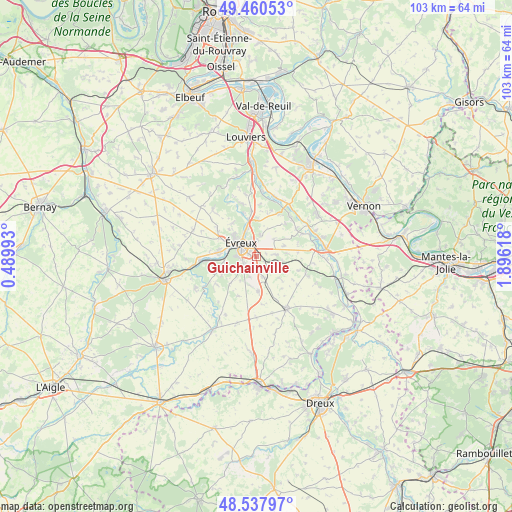
Guichainville GPS coordinates[2]
49° 0' 5.004" North, 1° 11' 34.98" East
| Map corner | latitude | longitude |
|---|---|---|
| Upper-left | 49.46053°, | 0.48993° |
| Center: | 49.00139°, | 1.19305° |
| Lower-right: | 48.53797°, | 1.89618° |
| Map W x H: | 102.6×102.6 km | = 63.8×63.8mi |
| max Lat: | 51.07786° ⇑20.3% North |
| Guichainville: | 49.00139° |
| min Lat: | ⇓79.7% South 41.3874° |
| min Long | Guichainville | max Long |
| -5.08615° | 1.19305° | 9.52242° |
| W 33.2%⇐ | ⇒66.8% E |
Elevation
Elevation of Guichainville is 135 m = 443 ft, and this is 58.7 m = 193 ft below average elevation for this country.
| Max E: |
2333 m = 7654 ft | 49.2% |
| Avg. | 193.7 m = 635 ft | |
| Guichainville | 135 m = 443 ft | |
Min E: |
-1 m = -3 ft | 50.8% |
See also: France elevation on elevation.city.
Geographical zone
Guichainville is located in North temperate zone (between Tropic of Cancer and the Arctic Circle). Distance of this North polar circle is 1952.7 km =1213.4 mi to North.| Distance of | km | miles | from Guichainville |
|---|---|---|---|
| North Pole | 4558.6 | 2832.6 | to North |
| Arctic Circle | 1952.7 | 1213.4 | to North |
| Tropic Cancer | 2842.5 | 1766.2 | to South |
| Equator | 5448.4 | 3385.5 | to South |


Nearby cities:
15 places around Guichainville: (largest is in red/bold)
• Arnières-sur-Iton
6.5 km =4 mi,  265°
265°
• Aviron
7.8 km =4.8 mi,  314°
314°
• Cierrey
6.1 km =3.8 mi,  84°
84°
• Garencières
7.3 km =4.5 mi,  133°
133°
• Gauciel
5 km =3.1 mi,  45°
45°
• Gravigny
6 km =3.7 mi,  343°
343°
• Huest
4.2 km =2.6 mi,  12°
12°
• Le Plessis-Grohan
7.5 km =4.7 mi,  216°
216°
• Le Val-David
4.6 km =2.9 mi,  115°
115°
• Le Vieil-Évreux
3.3 km =2.1 mi, 83°
• Miserey
6 km =3.7 mi,  68°
68°
• Prey
4.4 km =2.7 mi,  164°
164°
• Reuilly
8.8 km =5.5 mi,  15°
15°
• Saint-Sébastien-de-Morsent
7.8 km =4.8 mi,  277°
277°
• Évreux
4 km =2.5 mi, 309°
Sources, notices
• [Note1] Compared only with cities in France existing in our database
• [Src1] Map data: © OpenStreetMap contributors (CC-BY-SA)
• [Src2] Other city data from geonames.org with taken over terms of usage.
• [Src3] Geographical zone / Annual Mean Temperature by Robert A. Rohde @ Wikipedia
