Évreux geodata
Évreux (Normandy) is a seat of a second-order administrative division; located in France in Europe/Paris (GMT+2) time zone. With population of 57,795 people, there are 91 cities with bigger population in this country. Compared to other cities in France, 80.3% of cities are located further ↓South; 67.3% of cities are located further →East and 73.1% of cities have higher elevation than Évreux. Note1
Administrative division(s):
- Level 1: Normandy
- Level 2: Département de l'Eure
- Level 3: Arrondissement d’Évreux
- Level 4: Évreux


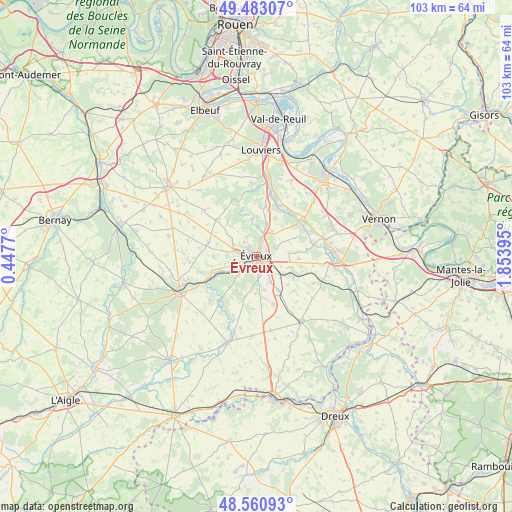
Évreux GPS coordinates[2]
49° 1' 26.904" North, 1° 9' 2.952" East
| Map corner | latitude | longitude |
|---|---|---|
| Upper-left | 49.48307°, | 0.4477° |
| Center: | 49.02414°, | 1.15082° |
| Lower-right: | 48.56093°, | 1.85395° |
| Map W x H: | 102.5×102.5 km | = 63.7×63.7mi |
| max Lat: | 51.07786° ⇑19.7% North |
| Évreux: | 49.02414° |
| min Lat: | ⇓80.3% South 41.3874° |
| min Long | Évreux | max Long |
| -5.08615° | 1.15082° | 9.52242° |
| W 32.7%⇐ | ⇒67.3% E |
Elevation
Elevation of Évreux is 71 m = 233 ft, and this is 122.7 m = 403 ft below average elevation for this country.
| Max E: |
2333 m = 7654 ft | 73.1% |
| Avg. | 193.7 m = 635 ft | |
| Évreux | 71 m = 233 ft | |
Min E: |
-1 m = -3 ft | 26.9% |
See also: Évreux elevation on elevation.city.
Geographical zone
Évreux is located in North temperate zone (between Tropic of Cancer and the Arctic Circle). Distance of this North polar circle is 1950.2 km =1211.8 mi to North.| Distance of | km | miles | from Évreux |
|---|---|---|---|
| North Pole | 4556.1 | 2831 | to North |
| Arctic Circle | 1950.2 | 1211.8 | to North |
| Tropic Cancer | 2845.1 | 1767.9 | to South |
| Equator | 5451 | 3387.1 | to South |


Nearby cities:
15 places around Évreux: (largest is in red/bold)
• Arnières-sur-Iton
4.6 km =2.9 mi,  228°
228°
• Aulnay-sur-Iton
7.4 km =4.6 mi,  244°
244°
• Aviron
3.8 km =2.4 mi,  319°
319°
• Gauciel
6.7 km =4.2 mi,  81°
81°
• Gauville-la-Campagne
5 km =3.1 mi,  297°
297°
• Gravigny
3.5 km =2.2 mi,  23°
23°
• Guichainville
4 km =2.5 mi,  129°
129°
• Huest
4.3 km =2.7 mi,  68°
68°
• Le Boulay-Morin
7 km =4.3 mi, 19°
• Le Vieil-Évreux
6.7 km =4.2 mi,  109°
109°
• Normanville
6.1 km =3.8 mi,  5°
5°
• Prey
8 km =5 mi,  147°
147°
• Reuilly
8 km =5 mi,  41°
41°
• Saint-Sébastien-de-Morsent
4.9 km =3 mi,  252°
252°
• Émalleville
8.2 km =5.1 mi,  4°
4°
Sources, notices
• [Note1] Compared only with cities in France existing in our database
• [Src1] Map data: © OpenStreetMap contributors (CC-BY-SA)
• [Src2] Other city data from geonames.org with taken over terms of usage.
• [Src3] Geographical zone / Annual Mean Temperature by Robert A. Rohde @ Wikipedia
