Barcelonne-du-Gers geodata
Barcelonne-du-Gers (Occitanie) is a populated place; located in France in Europe/Paris (GMT+2) time zone. With population of 1,379 people, there are 6685 cities with bigger population in this country. Compared to other cities in France, 90.3% of cities are located further ↑North; 80.1% of cities are located further →East and 67% of cities have higher elevation than Barcelonne-du-Gers. Note1
Administrative division(s):
- Level 1: Occitanie
- Level 2: Gers
- Level 3: Arrondissement de Mirande
- Level 4: Barcelonne-du-Gers


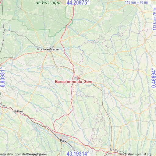
Barcelonne-du-Gers GPS coordinates[2]
43° 42' 12.96" North, 0° 14' 10.284" West
| Map corner | latitude | longitude |
|---|---|---|
| Upper-left | 44.20975°, | -0.93931° |
| Center: | 43.7036°, | -0.23619° |
| Lower-right: | 43.19314°, | 0.46694° |
| Map W x H: | 113×113 km | = 70.2×70.2mi |
| max Lat: | 51.07786° ⇑90.3% North |
| Barcelonne-du-Gers: | 43.7036° |
| min Lat: | ⇓9.7% South 41.3874° |
| min Long | Barcelonne-du-G | max Long |
| -5.08615° | -0.23619° | 9.52242° |
| W 19.9%⇐ | ⇒80.1% E |
Elevation
Elevation of Barcelonne-du-Gers is 85 m = 279 ft, and this is 108.7 m = 357 ft below average elevation for this country.
| Max E: |
2333 m = 7654 ft | 67% |
| Avg. | 193.7 m = 635 ft | |
| Barcelonne-du-Gers | 85 m = 279 ft | |
Min E: |
-1 m = -3 ft | 33% |
See also: France elevation on elevation.city.
Geographical zone
Barcelonne-du-Gers is located in North temperate zone (between Tropic of Cancer and the Arctic Circle). Distance of this Northern Tropic circle is 2253.5 km =1400.3 mi to South.| Distance of | km | miles | from Barcelonne-du-Gers |
|---|---|---|---|
| North Pole | 5147.7 | 3198.6 | to North |
| Arctic Circle | 2541.8 | 1579.4 | to North |
| Tropic Cancer | 2253.5 | 1400.3 | to South |
| Equator | 4859.4 | 3019.5 | to South |


Nearby cities:
15 places around Barcelonne-du-Gers: (largest is in red/bold)
• Cazères-sur-l’Adour
9.1 km =5.7 mi,  315°
315°
• Duhort-Bachen
7.3 km =4.5 mi,  288°
288°
• Eugénie-les-Bains
11.5 km =7.1 mi,  265°
265°
• Garlin
16.3 km =10.1 mi,  190°
190°
• Geaune
13.4 km =8.3 mi,  238°
238°
• Grenade-sur-l’Adour
17.6 km =10.9 mi,  297°
297°
• Hontanx
13.8 km =8.6 mi,  347°
347°
• Larrivière-Saint-Savin
16.1 km =10 mi, 295°
• Le Houga
9.2 km =5.7 mi,  30°
30°
• Nogaro
17.4 km =10.8 mi,  69°
69°
• Pujo-le-Plan
18.5 km =11.5 mi,  335°
335°
• Renung
10.7 km =6.6 mi, 296°
• Riscle
13.2 km =8.2 mi,  113°
113°
• Sainte-Marie-de-Gosse
17.1 km =10.6 mi,  179°
179°
• Viella
14 km =8.7 mi,  146°
146°
Sources, notices
• [Note1] Compared only with cities in France existing in our database
• [Src1] Map data: © OpenStreetMap contributors (CC-BY-SA)
• [Src2] Other city data from geonames.org with taken over terms of usage.
• [Src3] Geographical zone / Annual Mean Temperature by Robert A. Rohde @ Wikipedia
