Garlan geodata
Garlan (Brittany) is a populated place; located in France in Europe/Paris (GMT+2) time zone. With population of 906 people, there are 9605 cities with bigger population in this country. Compared to other cities in France, 70.9% of cities are located further ↓South; 98.7% of cities are located further →East and 64.9% of cities have higher elevation than Garlan. Note1
Administrative division(s):
- Level 1: Brittany
- Level 2: Département du Finistère
- Level 3: Arrondissement de Morlaix
- Level 4: Garlan


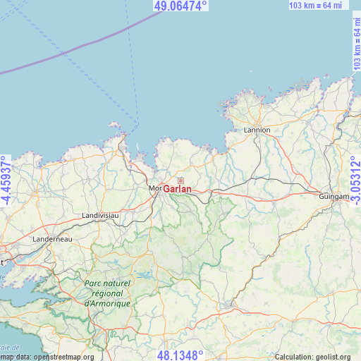
Garlan GPS coordinates[2]
48° 36' 6.876" North, 3° 45' 22.5" West
| Map corner | latitude | longitude |
|---|---|---|
| Upper-left | 49.06474°, | -4.45937° |
| Center: | 48.60191°, | -3.75625° |
| Lower-right: | 48.1348°, | -3.05312° |
| Map W x H: | 103.4×103.4 km | = 64.2×64.2mi |
| max Lat: | 51.07786° ⇑29.1% North |
| Garlan: | 48.60191° |
| min Lat: | ⇓70.9% South 41.3874° |
| min Long | Garlan | max Long |
| -5.08615° | -3.75625° | 9.52242° |
| W 1.3%⇐ | ⇒98.7% E |
Elevation
Elevation of Garlan is 90 m = 295 ft, and this is 103.7 m = 340 ft below average elevation for this country.
| Max E: |
2333 m = 7654 ft | 64.9% |
| Avg. | 193.7 m = 635 ft | |
| Garlan | 90 m = 295 ft | |
Min E: |
-1 m = -3 ft | 35.1% |
See also: France elevation on elevation.city.
Geographical zone
Garlan is located in North temperate zone (between Tropic of Cancer and the Arctic Circle). Distance of this North polar circle is 1997.1 km =1240.9 mi to North.| Distance of | km | miles | from Garlan |
|---|---|---|---|
| North Pole | 4603 | 2860.2 | to North |
| Arctic Circle | 1997.1 | 1240.9 | to North |
| Tropic Cancer | 2798.1 | 1738.7 | to South |
| Equator | 5404 | 3357.9 | to South |


Nearby cities:
15 places around Garlan: (largest is in red/bold)
• Guimaëc
8 km =5 mi,  26°
26°
• Lanmeur
5.8 km =3.6 mi, 30°
• Locquénolé
8.1 km =5 mi,  289°
289°
• Morlaix
5.9 km =3.7 mi,  242°
242°
• Plestin-les-Grèves
11.2 km =7 mi,  55°
55°
• Plouezoc'h
5.7 km =3.5 mi,  308°
308°
• Plougonven
9.9 km =6.2 mi,  162°
162°
• Plouigneau
5.7 km =3.5 mi,  133°
133°
• Plourin-lès-Morlaix
7.9 km =4.9 mi,  194°
194°
• Plouégat-Guérand
6.8 km =4.2 mi,  76°
76°
• Plouégat-Moysan
11 km =6.8 mi,  110°
110°
• Saint-Jean-du-Doigt
10.9 km =6.8 mi,  355°
355°
• Saint-Martin-des-Champs
6 km =3.7 mi,  249°
249°
• Sainte-Sève
9 km =5.6 mi, 244°
• Taulé
10.6 km =6.6 mi,  268°
268°
Sources, notices
• [Note1] Compared only with cities in France existing in our database
• [Src1] Map data: © OpenStreetMap contributors (CC-BY-SA)
• [Src2] Other city data from geonames.org with taken over terms of usage.
• [Src3] Geographical zone / Annual Mean Temperature by Robert A. Rohde @ Wikipedia
