Paulhac geodata
Paulhac (Occitanie) is a populated place; located in France in Europe/Paris (GMT+2) time zone. With population of 1,032 people, there are 8599 cities with bigger population in this country. Compared to other cities in France, 89.7% of cities are located further ↑North; 62.3% of cities are located further →East and 62.5% of cities have lower elevation than Paulhac. Note1
Administrative division(s):
- Level 1: Occitanie
- Level 2: Haute-Garonne
- Level 3: Arrondissement de Toulouse
- Level 4: Paulhac


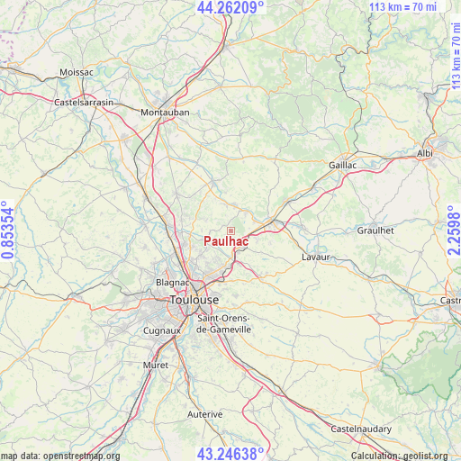
Paulhac GPS coordinates[2]
43° 45' 23.004" North, 1° 33' 24.012" East
| Map corner | latitude | longitude |
|---|---|---|
| Upper-left | 44.26209°, | 0.85354° |
| Center: | 43.75639°, | 1.55667° |
| Lower-right: | 43.24638°, | 2.2598° |
| Map W x H: | 112.9×112.9 km | = 70.2×70.2mi |
| max Lat: | 51.07786° ⇑89.7% North |
| Paulhac: | 43.75639° |
| min Lat: | ⇓10.3% South 41.3874° |
| min Long | Paulhac | max Long |
| -5.08615° | 1.55667° | 9.52242° |
| W 37.7%⇐ | ⇒62.3% E |
Elevation
Elevation of Paulhac is 182 m = 597 ft, and this is 11.7 m = 38 ft below average elevation for this country.
| Max E: |
2333 m = 7654 ft | 37.5% |
| Avg. | 193.7 m = 635 ft | |
| Paulhac | 182 m = 597 ft | |
Min E: |
-1 m = -3 ft | 62.5% |
See also: France elevation on elevation.city.
Geographical zone
Paulhac is located in North temperate zone (between Tropic of Cancer and the Arctic Circle). Distance of this Northern Tropic circle is 2259.3 km =1403.9 mi to South.| Distance of | km | miles | from Paulhac |
|---|---|---|---|
| North Pole | 5141.8 | 3195 | to North |
| Arctic Circle | 2535.9 | 1575.7 | to North |
| Tropic Cancer | 2259.3 | 1403.9 | to South |
| Equator | 4865.3 | 3023.2 | to South |


Nearby cities:
15 places around Paulhac: (largest is in red/bold)
• Bazus
4.1 km =2.5 mi,  233°
233°
• Bessières
6.2 km =3.9 mi,  40°
40°
• Buzet-sur-Tarn
6.7 km =4.2 mi,  67°
67°
• Gargas
7.1 km =4.4 mi,  270°
270°
• Garidech
5.1 km =3.2 mi,  176°
176°
• La Magdelaine-sur-Tarn
6.2 km =3.9 mi,  350°
350°
• Labastide-Saint-Sernin
7.3 km =4.5 mi,  253°
253°
• Lapeyrouse-Fossat
7.3 km =4.5 mi,  210°
210°
• Mirepoix-sur-Tarn
6.6 km =4.1 mi,  9°
9°
• Montastruc-la-Conseillère
4.9 km =3 mi,  146°
146°
• Montberon
7.7 km =4.8 mi, 233°
• Montjoire
2.3 km =1.4 mi,  307°
307°
• Roquesérière
6.9 km =4.3 mi,  110°
110°
• Vacquiers
6.5 km =4 mi,  290°
290°
• Villariès
5.3 km =3.3 mi,  262°
262°
Sources, notices
• [Note1] Compared only with cities in France existing in our database
• [Src1] Map data: © OpenStreetMap contributors (CC-BY-SA)
• [Src2] Other city data from geonames.org with taken over terms of usage.
• [Src3] Geographical zone / Annual Mean Temperature by Robert A. Rohde @ Wikipedia
