Gaillon-sur-Montcient geodata
Gaillon-sur-Montcient (Île-de-France) is a populated place; located in France in Europe/Paris (GMT+2) time zone. With population of 660 people, there are 12381 cities with bigger population in this country. Compared to other cities in France, 80.4% of cities are located further ↓South; 58.3% of cities are located further →East and 64% of cities have higher elevation than Gaillon-sur-Montcient. Note1
Administrative division(s):
- Level 1: Île-de-France
- Level 2: Yvelines
- Level 3: Arrondissement de Mantes-la-Jolie
- Level 4: Gaillon-sur-Montcient
Current local time in Gaillon-sur-Montcient:
03:13 PM, WednesdayDifference from your time zone: hours


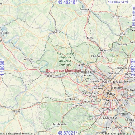
Gaillon-sur-Montcient GPS coordinates[2]
49° 1' 59.988" North, 1° 54' 0" East
| Map corner | latitude | longitude |
|---|---|---|
| Upper-left | 49.49218°, | 1.19688° |
| Center: | 49.03333°, | 1.9° |
| Lower-right: | 48.57021°, | 2.60313° |
| Map W x H: | 102.5×102.5 km | = 63.7×63.7mi |
| max Lat: | 51.07786° ⇑19.6% North |
| Gaillon-sur-Montcient: | 49.03333° |
| min Lat: | ⇓80.4% South 41.3874° |
| min Long | Gaillon-sur-Mon | max Long |
| -5.08615° | 1.9° | 9.52242° |
| W 41.7%⇐ | ⇒58.3% E |
Elevation
Elevation of Gaillon-sur-Montcient is 92 m = 302 ft, and this is 101.7 m = 334 ft below average elevation for this country.
| Max E: |
2333 m = 7654 ft | 64% |
| Avg. | 193.7 m = 635 ft | |
| Gaillon-sur-Montcient | 92 m = 302 ft | |
Min E: |
-1 m = -3 ft | 36% |
See also: France elevation on elevation.city.
Geographical zone
Gaillon-sur-Montcient is located in North temperate zone (between Tropic of Cancer and the Arctic Circle). Distance of this North polar circle is 1949.2 km =1211.2 mi to North.| Distance of | km | miles | from Gaillon-sur-Montcient |
|---|---|---|---|
| North Pole | 4555.1 | 2830.4 | to North |
| Arctic Circle | 1949.2 | 1211.2 | to North |
| Tropic Cancer | 2846.1 | 1768.5 | to South |
| Equator | 5452 | 3387.7 | to South |


Nearby cities:
15 places around Gaillon-sur-Montcient: (largest is in red/bold)
• Condécourt
3.2 km =2 mi,  75°
75°
• Hardricourt
2.9 km =1.8 mi,  188°
188°
• Jambville
3.7 km =2.3 mi,  291°
291°
• Les Mureaux
4.7 km =2.9 mi,  171°
171°
• Longuesse
3.9 km =2.4 mi,  36°
36°
• Menucourt
5.9 km =3.7 mi,  95°
95°
• Meulan-en-Yvelines
2.9 km =1.8 mi, 171°
• Mézy-sur-Seine
3.9 km =2.4 mi,  198°
198°
• Oinville-sur-Montcient
3.8 km =2.4 mi,  259°
259°
• Sagy
4.2 km =2.6 mi,  64°
64°
• Seraincourt
2.4 km =1.5 mi,  276°
276°
• Tessancourt-sur-Aubette
2 km =1.2 mi,  125°
125°
• Vaux-sur-Seine
5.6 km =3.5 mi,  114°
114°
• Vigny
5.5 km =3.4 mi,  21°
21°
• Évecquemont
3.9 km =2.4 mi,  123°
123°
Sources, notices
• [Note1] Compared only with cities in France existing in our database
• [Src1] Map data: © OpenStreetMap contributors (CC-BY-SA)
• [Src2] Other city data from geonames.org with taken over terms of usage.
• [Src3] Geographical zone / Annual Mean Temperature by Robert A. Rohde @ Wikipedia
