Vaux-sur-Seine geodata
Vaux-sur-Seine (Île-de-France) is a populated place; located in France in Europe/Paris (GMT+2) time zone. With population of 4,600 people, there are 2148 cities with bigger population in this country. Compared to other cities in France, 80% of cities are located further ↓South; 57.5% of cities are located further →East and 54.8% of cities have higher elevation than Vaux-sur-Seine. Note1
Administrative division(s):
- Level 1: Île-de-France
- Level 2: Yvelines
- Level 3: Arrondissement de Mantes-la-Jolie
- Level 4: Vaux-sur-Seine


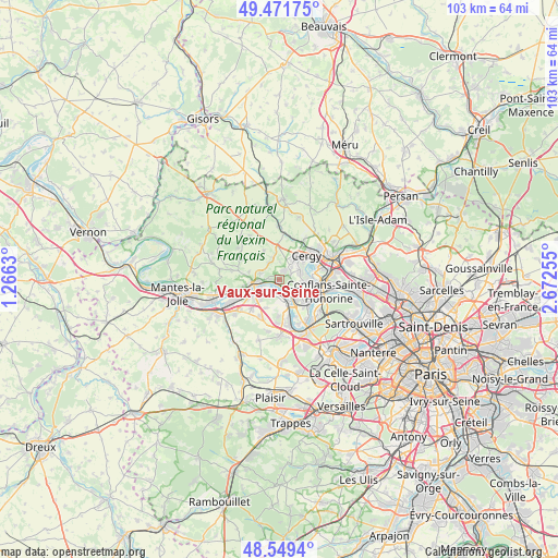
Vaux-sur-Seine GPS coordinates[2]
49° 0' 45.756" North, 1° 58' 9.912" East
| Map corner | latitude | longitude |
|---|---|---|
| Upper-left | 49.47175°, | 1.2663° |
| Center: | 49.01271°, | 1.96942° |
| Lower-right: | 48.5494°, | 2.67255° |
| Map W x H: | 102.6×102.6 km | = 63.8×63.8mi |
| max Lat: | 51.07786° ⇑20% North |
| Vaux-sur-Seine: | 49.01271° |
| min Lat: | ⇓80% South 41.3874° |
| min Long | Vaux-sur-Seine | max Long |
| -5.08615° | 1.96942° | 9.52242° |
| W 42.5%⇐ | ⇒57.5% E |
Elevation
Elevation of Vaux-sur-Seine is 117 m = 384 ft, and this is 76.7 m = 252 ft below average elevation for this country.
| Max E: |
2333 m = 7654 ft | 54.8% |
| Avg. | 193.7 m = 635 ft | |
| Vaux-sur-Seine | 117 m = 384 ft | |
Min E: |
-1 m = -3 ft | 45.2% |
See also: France elevation on elevation.city.
Geographical zone
Vaux-sur-Seine is located in North temperate zone (between Tropic of Cancer and the Arctic Circle). Distance of this North polar circle is 1951.5 km =1212.6 mi to North.| Distance of | km | miles | from Vaux-sur-Seine |
|---|---|---|---|
| North Pole | 4557.4 | 2831.8 | to North |
| Arctic Circle | 1951.5 | 1212.6 | to North |
| Tropic Cancer | 2843.8 | 1767.1 | to South |
| Equator | 5449.7 | 3386.3 | to South |


Nearby cities:
15 places around Vaux-sur-Seine: (largest is in red/bold)
• Boisemont
3 km =1.9 mi,  62°
62°
• Condécourt
3.7 km =2.3 mi,  326°
326°
• Courdimanche
3.4 km =2.1 mi,  42°
42°
• Hardricourt
5.5 km =3.4 mi,  264°
264°
• Jouy-le-Moutier
5.2 km =3.2 mi,  92°
92°
• Les Mureaux
4.9 km =3 mi,  241°
241°
• Menucourt
1.9 km =1.2 mi,  24°
24°
• Meulan-en-Yvelines
4.7 km =2.9 mi, 263°
• Sagy
4.3 km =2.7 mi,  343°
343°
• Tessancourt-sur-Aubette
3.6 km =2.2 mi,  288°
288°
• Triel-sur-Seine
4.7 km =2.9 mi,  144°
144°
• Vauréal
5.2 km =3.2 mi, 63°
• Verneuil-sur-Seine
4.3 km =2.7 mi,  184°
184°
• Vernouillet
4.7 km =2.9 mi,  169°
169°
• Évecquemont
1.8 km =1.1 mi,  275°
275°
Sources, notices
• [Note1] Compared only with cities in France existing in our database
• [Src1] Map data: © OpenStreetMap contributors (CC-BY-SA)
• [Src2] Other city data from geonames.org with taken over terms of usage.
• [Src3] Geographical zone / Annual Mean Temperature by Robert A. Rohde @ Wikipedia
