Frontenas geodata
Frontenas (Auvergne-Rhône-Alpes) is a populated place; located in France in Europe/Paris (GMT+2) time zone. With population of 869 people, there are 9902 cities with bigger population in this country. Compared to other cities in France, 67.2% of cities are located further ↑North; 73% of cities are located further ←West and 86.6% of cities have lower elevation than Frontenas. Note1
Administrative division(s):
- Level 1: Auvergne-Rhône-Alpes
- Level 2: Département du Rhône
- Level 3: Arrondissement de Villefranche-sur-Saône
- Level 4: Frontenas


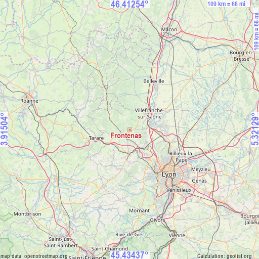
Frontenas GPS coordinates[2]
45° 55' 32.196" North, 4° 37' 5.376" East
| Map corner | latitude | longitude |
|---|---|---|
| Upper-left | 46.41254°, | 3.91504° |
| Center: | 45.92561°, | 4.61816° |
| Lower-right: | 45.43437°, | 5.32129° |
| Map W x H: | 108.8×108.8 km | = 67.6×67.6mi |
| max Lat: | 51.07786° ⇑67.2% North |
| Frontenas: | 45.92561° |
| min Lat: | ⇓32.8% South 41.3874° |
| min Long | Frontenas | max Long |
| -5.08615° | 4.61816° | 9.52242° |
| W 73%⇐ | ⇒27% E |
Elevation
Elevation of Frontenas is 368 m = 1207 ft, and this is 174.3 m = 572 ft above average elevation for this country.
| Max E: |
2333 m = 7654 ft | 13.4% |
| Frontenas | 368 m 1207 ft | |
| Avg. | 193.7 m = 635 ft | |
Min E: |
-1 m = -3 ft | 86.6% |
See also: France elevation on elevation.city.
Geographical zone
Frontenas is located in North temperate zone (between Tropic of Cancer and the Arctic Circle). Distance of this North polar circle is 2294.7 km =1425.9 mi to North.| Distance of | km | miles | from Frontenas |
|---|---|---|---|
| North Pole | 4900.6 | 3045.1 | to North |
| Arctic Circle | 2294.7 | 1425.9 | to North |
| Tropic Cancer | 2500.5 | 1553.7 | to South |
| Equator | 5106.4 | 3173 | to South |


Nearby cities:
15 places around Frontenas: (largest is in red/bold)
• Alix
3.1 km =1.9 mi,  117°
117°
• Bagnols
1.2 km =0.7 mi,  222°
222°
• Charnay
5.5 km =3.4 mi,  135°
135°
• Chessy
4.3 km =2.7 mi,  174°
174°
• Châtillon
5.8 km =3.6 mi,  158°
158°
• Jarnioux
4.4 km =2.7 mi,  9°
9°
• Lachassagne
5.4 km =3.4 mi,  90°
90°
• Le Bois-d'Oingt
2.9 km =1.8 mi,  251°
251°
• Liergues
6.1 km =3.8 mi,  33°
33°
• Marcy
5.1 km =3.2 mi,  103°
103°
• Oingt
3.7 km =2.3 mi,  313°
313°
• Pouilly-le-Monial
4.2 km =2.6 mi, 32°
• Saint-Laurent-d’Oingt
4.7 km =2.9 mi,  296°
296°
• Theizé
1.6 km =1 mi,  354°
354°
• Ville-sur-Jarnioux
4.1 km =2.5 mi, 349°
Sources, notices
• [Note1] Compared only with cities in France existing in our database
• [Src1] Map data: © OpenStreetMap contributors (CC-BY-SA)
• [Src2] Other city data from geonames.org with taken over terms of usage.
• [Src3] Geographical zone / Annual Mean Temperature by Robert A. Rohde @ Wikipedia
