Jarnioux geodata
Jarnioux (Auvergne-Rhône-Alpes) is a populated place; located in France in Europe/Paris (GMT+2) time zone. With population of 580 people, there are 13652 cities with bigger population in this country. Compared to other cities in France, 66.7% of cities are located further ↑North; 73.1% of cities are located further ←West and 80.8% of cities have lower elevation than Jarnioux. Note1
Administrative division(s):
- Level 1: Auvergne-Rhône-Alpes
- Level 2: Département du Rhône
- Level 3: Arrondissement de Villefranche-sur-Saône
- Level 4: Porte des Pierres Dorées


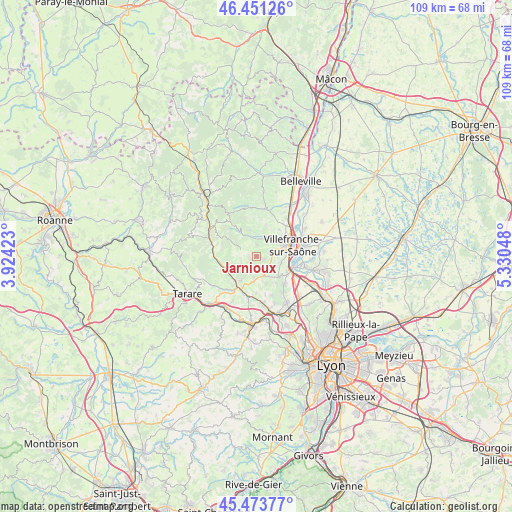
Jarnioux GPS coordinates[2]
45° 57' 52.812" North, 4° 37' 38.46" East
| Map corner | latitude | longitude |
|---|---|---|
| Upper-left | 46.45126°, | 3.92423° |
| Center: | 45.96467°, | 4.62735° |
| Lower-right: | 45.47377°, | 5.33048° |
| Map W x H: | 108.7×108.7 km | = 67.5×67.5mi |
| max Lat: | 51.07786° ⇑66.7% North |
| Jarnioux: | 45.96467° |
| min Lat: | ⇓33.3% South 41.3874° |
| min Long | Jarnioux | max Long |
| -5.08615° | 4.62735° | 9.52242° |
| W 73.1%⇐ | ⇒26.9% E |
Elevation
Elevation of Jarnioux is 299 m = 981 ft, and this is 105.3 m = 345 ft above average elevation for this country.
| Max E: |
2333 m = 7654 ft | 19.2% |
| Jarnioux | 299 m 981 ft | |
| Avg. | 193.7 m = 635 ft | |
Min E: |
-1 m = -3 ft | 80.8% |
See also: France elevation on elevation.city.
Geographical zone
Jarnioux is located in North temperate zone (between Tropic of Cancer and the Arctic Circle). Distance of this North polar circle is 2290.4 km =1423.2 mi to North.| Distance of | km | miles | from Jarnioux |
|---|---|---|---|
| North Pole | 4896.3 | 3042.4 | to North |
| Arctic Circle | 2290.4 | 1423.2 | to North |
| Tropic Cancer | 2504.9 | 1556.5 | to South |
| Equator | 5110.8 | 3175.7 | to South |


Nearby cities:
15 places around Jarnioux: (largest is in red/bold)
• Alix
6.1 km =3.8 mi,  160°
160°
• Bagnols
5.5 km =3.4 mi,  196°
196°
• Cogny
2.5 km =1.6 mi,  355°
355°
• Denicé
4.3 km =2.7 mi,  18°
18°
• Frontenas
4.4 km =2.7 mi,  189°
189°
• Gleizé
6 km =3.7 mi,  63°
63°
• Lacenas
2.8 km =1.7 mi,  28°
28°
• Liergues
2.8 km =1.7 mi,  74°
74°
• Oingt
3.8 km =2.4 mi,  242°
242°
• Pommiers
5.1 km =3.2 mi,  101°
101°
• Pouilly-le-Monial
1.7 km =1.1 mi,  118°
118°
• Rivolet
5 km =3.1 mi,  336°
336°
• Saint-Laurent-d’Oingt
5.4 km =3.4 mi,  245°
245°
• Theizé
2.9 km =1.8 mi, 196°
• Ville-sur-Jarnioux
1.5 km =0.9 mi,  257°
257°
Sources, notices
• [Note1] Compared only with cities in France existing in our database
• [Src1] Map data: © OpenStreetMap contributors (CC-BY-SA)
• [Src2] Other city data from geonames.org with taken over terms of usage.
• [Src3] Geographical zone / Annual Mean Temperature by Robert A. Rohde @ Wikipedia
