Le Bois-d'Oingt geodata
Le Bois-d'Oingt (Auvergne-Rhône-Alpes) is a populated place; located in France in Europe/Paris (GMT+2) time zone. With population of 2,161 people, there are 4453 cities with bigger population in this country. Compared to other cities in France, 67.4% of cities are located further ↑North; 72.6% of cities are located further ←West and 85.6% of cities have lower elevation than Le Bois-d'Oingt. Note1
Administrative division(s):
- Level 1: Auvergne-Rhône-Alpes
- Level 2: Département du Rhône
- Level 3: Arrondissement de Villefranche-sur-Saône
- Level 4: Val d'Oingt


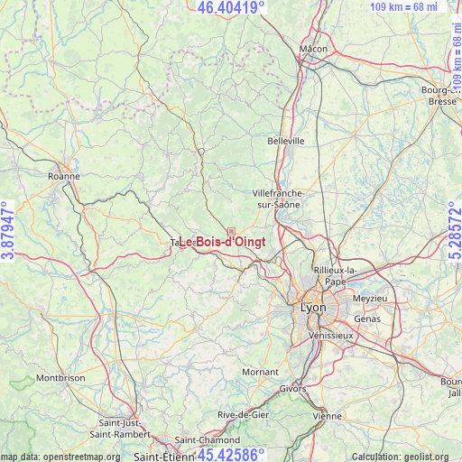
Le Bois-d'Oingt GPS coordinates[2]
45° 55' 1.848" North, 4° 34' 57.324" East
| Map corner | latitude | longitude |
|---|---|---|
| Upper-left | 46.40419°, | 3.87947° |
| Center: | 45.91718°, | 4.58259° |
| Lower-right: | 45.42586°, | 5.28572° |
| Map W x H: | 108.8×108.8 km | = 67.6×67.6mi |
| max Lat: | 51.07786° ⇑67.4% North |
| Le Bois-d'Oingt: | 45.91718° |
| min Lat: | ⇓32.6% South 41.3874° |
| min Long | Le Bois-d'Oingt | max Long |
| -5.08615° | 4.58259° | 9.52242° |
| W 72.6%⇐ | ⇒27.4% E |
Elevation
Elevation of Le Bois-d'Oingt is 354 m = 1161 ft, and this is 160.3 m = 526 ft above average elevation for this country.
| Max E: |
2333 m = 7654 ft | 14.4% |
| Le Bois-d'Oingt | 354 m 1161 ft | |
| Avg. | 193.7 m = 635 ft | |
Min E: |
-1 m = -3 ft | 85.6% |
See also: France elevation on elevation.city.
Geographical zone
Le Bois-d'Oingt is located in North temperate zone (between Tropic of Cancer and the Arctic Circle). Distance of this North polar circle is 2295.7 km =1426.5 mi to North.| Distance of | km | miles | from Le Bois-d'Oingt |
|---|---|---|---|
| North Pole | 4901.6 | 3045.7 | to North |
| Arctic Circle | 2295.7 | 1426.5 | to North |
| Tropic Cancer | 2499.6 | 1553.2 | to South |
| Equator | 5105.5 | 3172.4 | to South |


Nearby cities:
15 places around Le Bois-d'Oingt: (largest is in red/bold)
• Alix
5.6 km =3.5 mi,  95°
95°
• Bagnols
1.9 km =1.2 mi,  88°
88°
• Chessy
4.6 km =2.9 mi,  136°
136°
• Châtillon
6.6 km =4.1 mi,  132°
132°
• Frontenas
2.9 km =1.8 mi,  71°
71°
• Jarnioux
6.3 km =3.9 mi,  33°
33°
• Les Olmes
6.4 km =4 mi,  233°
233°
• Oingt
3.5 km =2.2 mi,  0°
0°
• Pouilly-le-Monial
6.7 km =4.2 mi,  48°
48°
• Saint-Laurent-d’Oingt
3.4 km =2.1 mi,  333°
333°
• Saint-Vérand
4.3 km =2.7 mi,  272°
272°
• Sarcey
4.7 km =2.9 mi,  210°
210°
• Ternand
5.1 km =3.2 mi,  306°
306°
• Theizé
3.6 km =2.2 mi, 46°
• Ville-sur-Jarnioux
5.3 km =3.3 mi,  21°
21°
Sources, notices
• [Note1] Compared only with cities in France existing in our database
• [Src1] Map data: © OpenStreetMap contributors (CC-BY-SA)
• [Src2] Other city data from geonames.org with taken over terms of usage.
• [Src3] Geographical zone / Annual Mean Temperature by Robert A. Rohde @ Wikipedia
