Saint-Ouen-l’Aumône geodata
Saint-Ouen-l’Aumône (Île-de-France) is a populated place; located in France in Europe/Paris (GMT+2) time zone. With population of 22,977 people, there are 390 cities with bigger population in this country. Compared to other cities in France, 80.7% of cities are located further ↓South; 55.5% of cities are located further →East and 89.9% of cities have higher elevation than Saint-Ouen-l’Aumône. Note1
Administrative division(s):
- Level 1: Île-de-France
- Level 2: Département du Val-d’Oise
- Level 3: Arrondissement de Pontoise
- Level 4: Saint-Ouen-l'Aumône


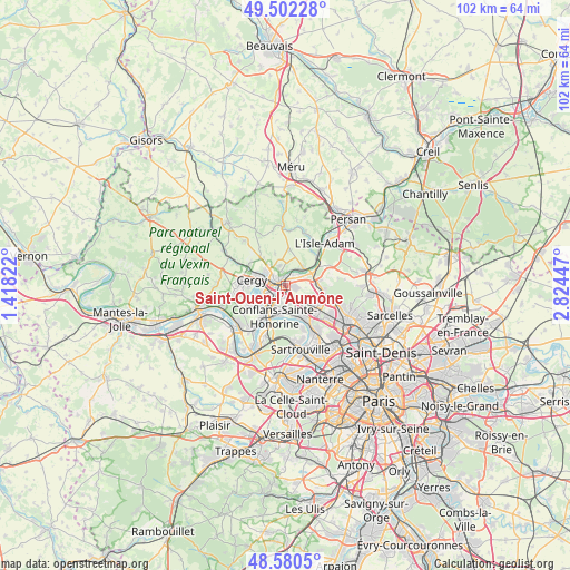
Saint-Ouen-l’Aumône GPS coordinates[2]
49° 2' 36.708" North, 2° 7' 16.824" East
| Map corner | latitude | longitude |
|---|---|---|
| Upper-left | 49.50228°, | 1.41822° |
| Center: | 49.04353°, | 2.12134° |
| Lower-right: | 48.5805°, | 2.82447° |
| Map W x H: | 102.5×102.5 km | = 63.7×63.7mi |
| max Lat: | 51.07786° ⇑19.3% North |
| Saint-Ouen-l’Aumône: | 49.04353° |
| min Lat: | ⇓80.7% South 41.3874° |
| min Long | Saint-Ouen-l’ | max Long |
| -5.08615° | 2.12134° | 9.52242° |
| W 44.5%⇐ | ⇒55.5% E |
Elevation
Elevation of Saint-Ouen-l’Aumône is 30 m = 98 ft, and this is 163.7 m = 537 ft below average elevation for this country.
| Max E: |
2333 m = 7654 ft | 89.9% |
| Avg. | 193.7 m = 635 ft | |
| Saint-Ouen-l’Aumône | 30 m = 98 ft | |
Min E: |
-1 m = -3 ft | 10.1% |
See also: France elevation on elevation.city.
Geographical zone
Saint-Ouen-l’Aumône is located in North temperate zone (between Tropic of Cancer and the Arctic Circle). Distance of this North polar circle is 1948 km =1210.4 mi to North.| Distance of | km | miles | from Saint-Ouen-l’Aumône |
|---|---|---|---|
| North Pole | 4553.9 | 2829.7 | to North |
| Arctic Circle | 1948 | 1210.4 | to North |
| Tropic Cancer | 2847.2 | 1769.2 | to South |
| Equator | 5453.1 | 3388.4 | to South |


Nearby cities:
15 places around Saint-Ouen-l’Aumône: (largest is in red/bold)
• Auvers-sur-Oise
4.7 km =2.9 mi,  48°
48°
• Bessancourt
6.4 km =4 mi,  95°
95°
• Cergy
3.4 km =2.1 mi,  256°
256°
• Cergy-Pontoise
3.2 km =2 mi, 260°
• Conflans-Sainte-Honorine
5 km =3.1 mi,  200°
200°
• Ennery
3.7 km =2.3 mi,  342°
342°
• Frépillon
6.2 km =3.9 mi,  81°
81°
• Génicourt
6.4 km =4 mi,  322°
322°
• Hérouville
6.5 km =4 mi,  7°
7°
• Méry-sur-Oise
5.4 km =3.4 mi,  71°
71°
• Neuville-sur-Oise
5 km =3.1 mi,  233°
233°
• Osny
5.2 km =3.2 mi,  304°
304°
• Pierrelaye
3.5 km =2.2 mi,  135°
135°
• Pontoise
1.7 km =1.1 mi,  294°
294°
• Éragny
3.4 km =2.1 mi,  207°
207°
Sources, notices
• [Note1] Compared only with cities in France existing in our database
• [Src1] Map data: © OpenStreetMap contributors (CC-BY-SA)
• [Src2] Other city data from geonames.org with taken over terms of usage.
• [Src3] Geographical zone / Annual Mean Temperature by Robert A. Rohde @ Wikipedia
