Fontenay-le-Pesnel geodata
Fontenay-le-Pesnel (Normandy) is a populated place; located in France in Europe/Paris (GMT+2) time zone. With population of 980 people, there are 8985 cities with bigger population in this country. Compared to other cities in France, 83.7% of cities are located further ↓South; 84.2% of cities are located further →East and 66.6% of cities have higher elevation than Fontenay-le-Pesnel. Note1
Administrative division(s):
- Level 1: Normandy
- Level 2: Calvados
- Level 3: Arrondissement de Bayeux
- Level 4: Fontenay-le-Pesnel


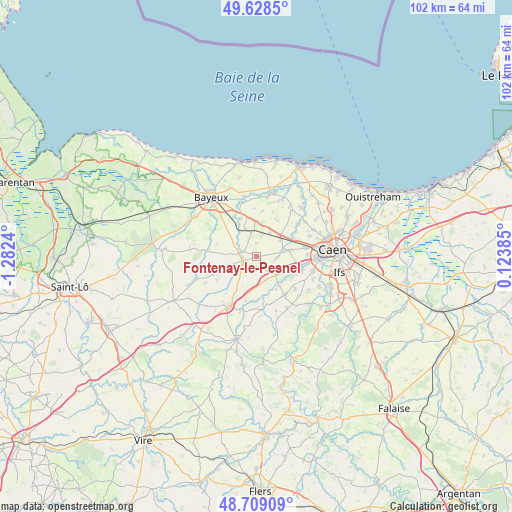
Fontenay-le-Pesnel GPS coordinates[2]
49° 10' 15.348" North, 0° 34' 45.372" West
| Map corner | latitude | longitude |
|---|---|---|
| Upper-left | 49.6285°, | -1.2824° |
| Center: | 49.17093°, | -0.57927° |
| Lower-right: | 48.70909°, | 0.12385° |
| Map W x H: | 102.2×102.2 km | = 63.5×63.5mi |
| max Lat: | 51.07786° ⇑16.3% North |
| Fontenay-le-Pesnel: | 49.17093° |
| min Lat: | ⇓83.7% South 41.3874° |
| min Long | Fontenay-le-Pes | max Long |
| -5.08615° | -0.57927° | 9.52242° |
| W 15.8%⇐ | ⇒84.2% E |
Elevation
Elevation of Fontenay-le-Pesnel is 86 m = 282 ft, and this is 107.7 m = 353 ft below average elevation for this country.
| Max E: |
2333 m = 7654 ft | 66.6% |
| Avg. | 193.7 m = 635 ft | |
| Fontenay-le-Pesnel | 86 m = 282 ft | |
Min E: |
-1 m = -3 ft | 33.4% |
See also: France elevation on elevation.city.
Geographical zone
Fontenay-le-Pesnel is located in North temperate zone (between Tropic of Cancer and the Arctic Circle). Distance of this North polar circle is 1933.9 km =1201.7 mi to North.| Distance of | km | miles | from Fontenay-le-Pesnel |
|---|---|---|---|
| North Pole | 4539.8 | 2820.9 | to North |
| Arctic Circle | 1933.9 | 1201.7 | to North |
| Tropic Cancer | 2861.4 | 1778 | to South |
| Equator | 5467.3 | 3397.2 | to South |


Nearby cities:
15 places around Fontenay-le-Pesnel: (largest is in red/bold)
• Audrieu
4.3 km =2.7 mi,  345°
345°
• Baron-sur-Odon
8.5 km =5.3 mi,  120°
120°
• Bretteville-l’Orgueilleuse
6.6 km =4.1 mi,  46°
46°
• Cheux
3.9 km =2.4 mi,  97°
97°
• Fontaine-Étoupefour
9.4 km =5.8 mi,  107°
107°
• Grainville-sur-Odon
5 km =3.1 mi,  134°
134°
• Missy
6 km =3.7 mi,  159°
159°
• Mouen
7.4 km =4.6 mi, 110°
• Noyers-Bocage
5.5 km =3.4 mi,  170°
170°
• Rots
9 km =5.6 mi,  59°
59°
• Saint-Manvieu
5.7 km =3.5 mi,  79°
79°
• Saint-Manvieu-Norrey
5.9 km =3.7 mi, 78°
• Tilly-sur-Seulles
3.4 km =2.1 mi,  279°
279°
• Tourville-sur-Odon
6.5 km =4 mi, 119°
• Verson
9.1 km =5.7 mi, 101°
Sources, notices
• [Note1] Compared only with cities in France existing in our database
• [Src1] Map data: © OpenStreetMap contributors (CC-BY-SA)
• [Src2] Other city data from geonames.org with taken over terms of usage.
• [Src3] Geographical zone / Annual Mean Temperature by Robert A. Rohde @ Wikipedia
