Morbier geodata
Morbier (Bourgogne-Franche-Comté) is a populated place; located in France in Europe/Paris (GMT+2) time zone. With population of 2,224 people, there are 4318 cities with bigger population in this country. Compared to other cities in France, 59.8% of cities are located further ↑North; 87.2% of cities are located further ←West and 98% of cities have lower elevation than Morbier. Note1
Administrative division(s):
- Level 1: Bourgogne-Franche-Comté
- Level 2: Jura
- Level 3: Arrondissement de Saint-Claude
- Level 4: Morbier


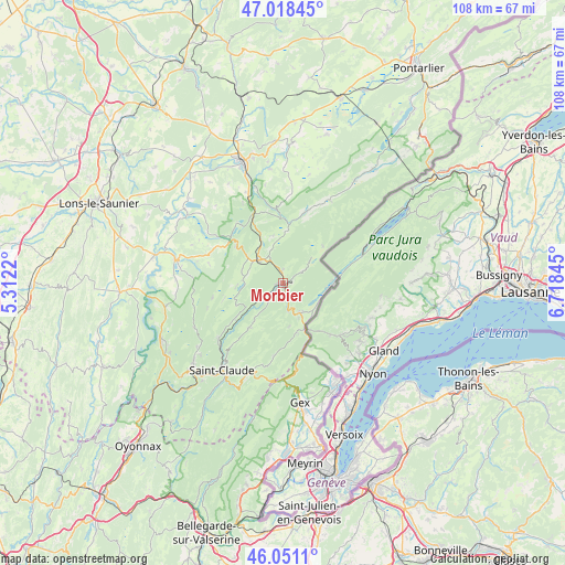
Morbier GPS coordinates[2]
46° 32' 12.948" North, 6° 0' 55.152" East
| Map corner | latitude | longitude |
|---|---|---|
| Upper-left | 47.01845°, | 5.3122° |
| Center: | 46.53693°, | 6.01532° |
| Lower-right: | 46.0511°, | 6.71845° |
| Map W x H: | 107.6×107.6 km | = 66.9×66.9mi |
| max Lat: | 51.07786° ⇑59.8% North |
| Morbier: | 46.53693° |
| min Lat: | ⇓40.2% South 41.3874° |
| min Long | Morbier | max Long |
| -5.08615° | 6.01532° | 9.52242° |
| W 87.2%⇐ | ⇒12.8% E |
Elevation
Elevation of Morbier is 821 m = 2694 ft, and this is 627.3 m = 2058 ft above average elevation for this country.
| Max E: |
2333 m = 7654 ft | 2% |
| Morbier | 821 m 2694 ft | |
| Avg. | 193.7 m = 635 ft | |
Min E: |
-1 m = -3 ft | 98% |
See also: France elevation on elevation.city.
Geographical zone
Morbier is located in North temperate zone (between Tropic of Cancer and the Arctic Circle). Distance of this North polar circle is 2226.8 km =1383.7 mi to North.| Distance of | km | miles | from Morbier |
|---|---|---|---|
| North Pole | 4832.6 | 3002.8 | to North |
| Arctic Circle | 2226.8 | 1383.7 | to North |
| Tropic Cancer | 2568.5 | 1596 | to South |
| Equator | 5174.4 | 3215.2 | to South |


Nearby cities:
15 places around Morbier: (largest is in red/bold)
• Bois-d’Amont
9.4 km =5.8 mi,  92°
92°
• Cize
22.1 km =13.7 mi,  340°
340°
• Clairvaux-les-Lacs
20.8 km =12.9 mi,  281°
281°
• Divonne-les-Bains
22 km =13.7 mi,  155°
155°
• Foncine-le-Haut
14.1 km =8.8 mi,  17°
17°
• La Chaux-du-Dombief
11.4 km =7.1 mi,  309°
309°
• Les Rousses
6.9 km =4.3 mi,  147°
147°
• Longchaumois
10.5 km =6.5 mi,  218°
218°
• Morez
1.5 km =0.9 mi, 147°
• Prémanon
8.2 km =5.1 mi,  178°
178°
• Saint-Claude
20.3 km =12.6 mi,  214°
214°
• Saint-Laurent-en-Grandvaux
7.2 km =4.5 mi,  315°
315°
• Septmoncel
20 km =12.4 mi,  203°
203°
• Sirod
21.9 km =13.6 mi,  353°
353°
• Valfin-lès-Saint-Claude
16.5 km =10.3 mi,  227°
227°
Sources, notices
• [Note1] Compared only with cities in France existing in our database
• [Src1] Map data: © OpenStreetMap contributors (CC-BY-SA)
• [Src2] Other city data from geonames.org with taken over terms of usage.
• [Src3] Geographical zone / Annual Mean Temperature by Robert A. Rohde @ Wikipedia
