Fayence geodata
Fayence (Provence-Alpes-Côte d'Azur) is a populated place; located in France in Europe/Paris (GMT+2) time zone. With population of 4,603 people, there are 2146 cities with bigger population in this country. Compared to other cities in France, 91.5% of cities are located further ↑North; 93% of cities are located further ←West and 87.1% of cities have lower elevation than Fayence. Note1
Administrative division(s):
- Level 1: Provence-Alpes-Côte d'Azur
- Level 2: Var
- Level 3: Arrondissement de Draguignan
- Level 4: Fayence


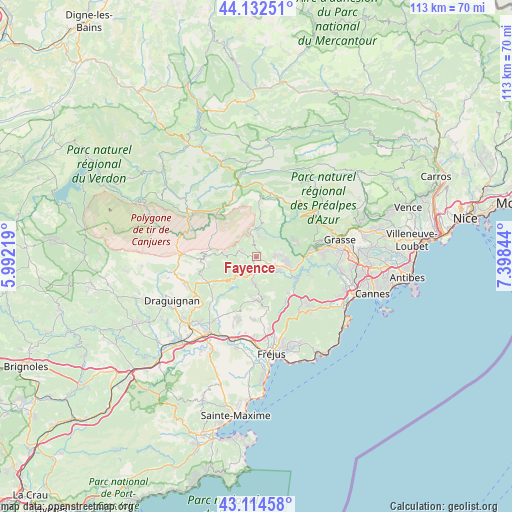
Fayence GPS coordinates[2]
43° 37' 32.52" North, 6° 41' 43.116" East
| Map corner | latitude | longitude |
|---|---|---|
| Upper-left | 44.13251°, | 5.99219° |
| Center: | 43.6257°, | 6.69531° |
| Lower-right: | 43.11458°, | 7.39844° |
| Map W x H: | 113.2×113.2 km | = 70.3×70.3mi |
| max Lat: | 51.07786° ⇑91.5% North |
| Fayence: | 43.6257° |
| min Lat: | ⇓8.5% South 41.3874° |
| min Long | Fayence | max Long |
| -5.08615° | 6.69531° | 9.52242° |
| W 93%⇐ | ⇒7% E |
Elevation
Elevation of Fayence is 375 m = 1230 ft, and this is 181.3 m = 595 ft above average elevation for this country.
| Max E: |
2333 m = 7654 ft | 12.9% |
| Fayence | 375 m 1230 ft | |
| Avg. | 193.7 m = 635 ft | |
Min E: |
-1 m = -3 ft | 87.1% |
See also: France elevation on elevation.city.
Geographical zone
Fayence is located in North temperate zone (between Tropic of Cancer and the Arctic Circle). Distance of this Northern Tropic circle is 2244.8 km =1394.9 mi to South.| Distance of | km | miles | from Fayence |
|---|---|---|---|
| North Pole | 5156.3 | 3204 | to North |
| Arctic Circle | 2550.5 | 1584.8 | to North |
| Tropic Cancer | 2244.8 | 1394.9 | to South |
| Equator | 4850.7 | 3014.1 | to South |


Nearby cities:
15 places around Fayence: (largest is in red/bold)
• Bagnols-en-Forêt
9.8 km =6.1 mi,  178°
178°
• Bargemon
11.8 km =7.3 mi,  266°
266°
• Cabris
14.7 km =9.1 mi,  76°
76°
• Callas
13.2 km =8.2 mi,  253°
253°
• Callian
4.6 km =2.9 mi,  94°
94°
• Claviers
10.9 km =6.8 mi,  255°
255°
• Le Tignet
12.2 km =7.6 mi, 82°
• Mons
7.4 km =4.6 mi,  11°
11°
• Montauroux
5.7 km =3.5 mi,  98°
98°
• Peymeinade
14.6 km =9.1 mi, 82°
• Saint-Cézaire-sur-Siagne
8.3 km =5.2 mi,  70°
70°
• Saint-Paul-en-Forêt
6.5 km =4 mi, 182°
• Saint-Vallier-de-Thiey
14.7 km =9.1 mi,  56°
56°
• Seillans
4.3 km =2.7 mi,  285°
285°
• Spéracèdes
13.4 km =8.3 mi, 79°
Sources, notices
• [Note1] Compared only with cities in France existing in our database
• [Src1] Map data: © OpenStreetMap contributors (CC-BY-SA)
• [Src2] Other city data from geonames.org with taken over terms of usage.
• [Src3] Geographical zone / Annual Mean Temperature by Robert A. Rohde @ Wikipedia
