Bargemon geodata
Bargemon (Provence-Alpes-Côte d'Azur) is a populated place; located in France in Europe/Paris (GMT+2) time zone. With population of 1,316 people, there are 6954 cities with bigger population in this country. Compared to other cities in France, 91.6% of cities are located further ↑North; 92% of cities are located further ←West and 91.6% of cities have lower elevation than Bargemon. Note1
Administrative division(s):
- Level 1: Provence-Alpes-Côte d'Azur
- Level 2: Var
- Level 3: Arrondissement de Draguignan
- Level 4: Bargemon


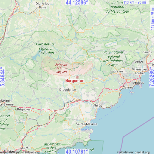
Bargemon GPS coordinates[2]
43° 37' 8.364" North, 6° 32' 58.452" East
| Map corner | latitude | longitude |
|---|---|---|
| Upper-left | 44.12586°, | 5.84644° |
| Center: | 43.61899°, | 6.54957° |
| Lower-right: | 43.10781°, | 7.25269° |
| Map W x H: | 113.2×113.2 km | = 70.3×70.3mi |
| max Lat: | 51.07786° ⇑91.6% North |
| Bargemon: | 43.61899° |
| min Lat: | ⇓8.4% South 41.3874° |
| min Long | Bargemon | max Long |
| -5.08615° | 6.54957° | 9.52242° |
| W 92%⇐ | ⇒8% E |
Elevation
Elevation of Bargemon is 465 m = 1526 ft, and this is 271.3 m = 890 ft above average elevation for this country.
| Max E: |
2333 m = 7654 ft | 8.4% |
| Bargemon | 465 m 1526 ft | |
| Avg. | 193.7 m = 635 ft | |
Min E: |
-1 m = -3 ft | 91.6% |
See also: France elevation on elevation.city.
Geographical zone
Bargemon is located in North temperate zone (between Tropic of Cancer and the Arctic Circle). Distance of this Northern Tropic circle is 2244.1 km =1394.4 mi to South.| Distance of | km | miles | from Bargemon |
|---|---|---|---|
| North Pole | 5157.1 | 3204.5 | to North |
| Arctic Circle | 2551.2 | 1585.2 | to North |
| Tropic Cancer | 2244.1 | 1394.4 | to South |
| Equator | 4850 | 3013.6 | to South |


Nearby cities:
15 places around Bargemon: (largest is in red/bold)
• Ampus
13.6 km =8.5 mi,  264°
264°
• Bagnols-en-Forêt
15 km =9.3 mi,  127°
127°
• Callas
3 km =1.9 mi,  197°
197°
• Claviers
2.2 km =1.4 mi,  149°
149°
• Draguignan
11.4 km =7.1 mi,  216°
216°
• Fayence
11.8 km =7.3 mi,  86°
86°
• Figanières
7 km =4.3 mi, 217°
• Flayosc
15.5 km =9.6 mi,  232°
232°
• La Motte
13.9 km =8.6 mi,  184°
184°
• Le Muy
16.3 km =10.1 mi, 175°
• Mons
15.5 km =9.6 mi,  58°
58°
• Montferrat
5.6 km =3.5 mi, 261°
• Saint-Paul-en-Forêt
12.8 km =8 mi,  116°
116°
• Seillans
7.8 km =4.8 mi,  75°
75°
• Trans-en-Provence
13.8 km =8.6 mi, 201°
Sources, notices
• [Note1] Compared only with cities in France existing in our database
• [Src1] Map data: © OpenStreetMap contributors (CC-BY-SA)
• [Src2] Other city data from geonames.org with taken over terms of usage.
• [Src3] Geographical zone / Annual Mean Temperature by Robert A. Rohde @ Wikipedia
