Bagnols-en-Forêt geodata
Bagnols-en-Forêt (Provence-Alpes-Côte d'Azur) is a populated place; located in France in Europe/Paris (GMT+2) time zone. With population of 1,810 people, there are 5233 cities with bigger population in this country. Compared to other cities in France, 92.6% of cities are located further ↑North; 93% of cities are located further ←West and 80.3% of cities have lower elevation than Bagnols-en-Forêt. Note1
Administrative division(s):
- Level 1: Provence-Alpes-Côte d'Azur
- Level 2: Var
- Level 3: Arrondissement de Draguignan
- Level 4: Bagnols-en-Forêt


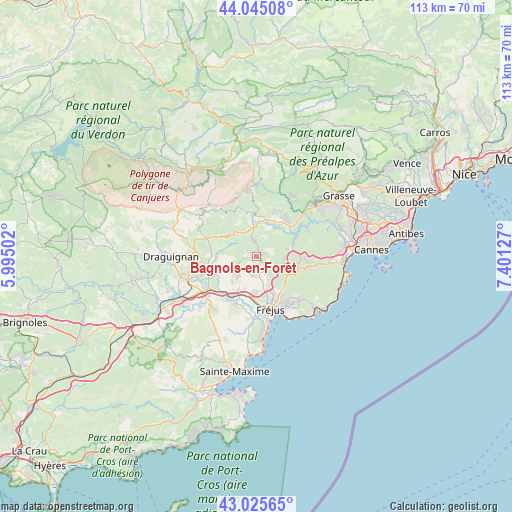
Bagnols-en-Forêt GPS coordinates[2]
43° 32' 15.072" North, 6° 41' 53.304" East
| Map corner | latitude | longitude |
|---|---|---|
| Upper-left | 44.04508°, | 5.99502° |
| Center: | 43.53752°, | 6.69814° |
| Lower-right: | 43.02565°, | 7.40127° |
| Map W x H: | 113.3×113.3 km | = 70.4×70.4mi |
| max Lat: | 51.07786° ⇑92.6% North |
| Bagnols-en-Forêt: | 43.53752° |
| min Lat: | ⇓7.4% South 41.3874° |
| min Long | Bagnols-en-For� | max Long |
| -5.08615° | 6.69814° | 9.52242° |
| W 93%⇐ | ⇒7% E |
Elevation
Elevation of Bagnols-en-Forêt is 293 m = 961 ft, and this is 99.3 m = 326 ft above average elevation for this country.
| Max E: |
2333 m = 7654 ft | 19.7% |
| Bagnols-en-Forêt | 293 m 961 ft | |
| Avg. | 193.7 m = 635 ft | |
Min E: |
-1 m = -3 ft | 80.3% |
See also: France elevation on elevation.city.
Geographical zone
Bagnols-en-Forêt is located in North temperate zone (between Tropic of Cancer and the Arctic Circle). Distance of this Northern Tropic circle is 2235 km =1388.8 mi to South.| Distance of | km | miles | from Bagnols-en-Forêt |
|---|---|---|---|
| North Pole | 5166.1 | 3210.1 | to North |
| Arctic Circle | 2560.3 | 1590.9 | to North |
| Tropic Cancer | 2235 | 1388.8 | to South |
| Equator | 4840.9 | 3008 | to South |


Nearby cities:
15 places around Bagnols-en-Forêt: (largest is in red/bold)
• Bargemon
15 km =9.3 mi,  307°
307°
• Callas
14.3 km =8.9 mi,  295°
295°
• Callian
10.4 km =6.5 mi,  25°
25°
• Claviers
13 km =8.1 mi, 303°
• Fayence
9.8 km =6.1 mi,  358°
358°
• Fréjus
12 km =7.5 mi,  165°
165°
• La Motte
14 km =8.7 mi,  249°
249°
• Le Muy
12.8 km =8 mi,  235°
235°
• Montauroux
10.5 km =6.5 mi, 31°
• Puget-sur-Argens
9.2 km =5.7 mi,  186°
186°
• Roquebrune-sur-Argens
11.6 km =7.2 mi,  204°
204°
• Saint-Cézaire-sur-Siagne
14.6 km =9.1 mi, 31°
• Saint-Paul-en-Forêt
3.3 km =2.1 mi,  351°
351°
• Saint-Raphaël
14.1 km =8.8 mi,  154°
154°
• Seillans
11.8 km =7.3 mi,  338°
338°
Sources, notices
• [Note1] Compared only with cities in France existing in our database
• [Src1] Map data: © OpenStreetMap contributors (CC-BY-SA)
• [Src2] Other city data from geonames.org with taken over terms of usage.
• [Src3] Geographical zone / Annual Mean Temperature by Robert A. Rohde @ Wikipedia
