Bailleul-Sir-Berthoult geodata
Bailleul-Sir-Berthoult (Hauts-de-France) is a populated place; located in France in Europe/Paris (GMT+2) time zone. With population of 1,199 people, there are 7541 cities with bigger population in this country. Compared to other cities in France, 95.9% of cities are located further ↓South; 55.7% of cities are located further ←West and 70.1% of cities have higher elevation than Bailleul-Sir-Berthoult. Note1
Administrative division(s):
- Level 1: Hauts-de-France
- Level 2: Pas-de-Calais
- Level 3: Arras
- Level 4: Bailleul-Sir-Berthoult


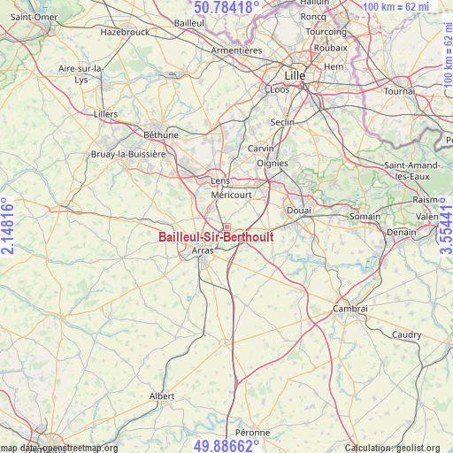
Bailleul-Sir-Berthoult GPS coordinates[2]
50° 20' 15.072" North, 2° 51' 4.644" East
| Map corner | latitude | longitude |
|---|---|---|
| Upper-left | 50.78418°, | 2.14816° |
| Center: | 50.33752°, | 2.85129° |
| Lower-right: | 49.88662°, | 3.55441° |
| Map W x H: | 99.8×99.8 km | = 62×62mi |
| max Lat: | 51.07786° ⇑4.1% North |
| Bailleul-Sir-Berthoult: | 50.33752° |
| min Lat: | ⇓95.9% South 41.3874° |
| min Long | Bailleul-Sir-Be | max Long |
| -5.08615° | 2.85129° | 9.52242° |
| W 55.7%⇐ | ⇒44.3% E |
Elevation
Elevation of Bailleul-Sir-Berthoult is 78 m = 256 ft, and this is 115.7 m = 380 ft below average elevation for this country.
| Max E: |
2333 m = 7654 ft | 70.1% |
| Avg. | 193.7 m = 635 ft | |
| Bailleul-Sir-Berthoult | 78 m = 256 ft | |
Min E: |
-1 m = -3 ft | 29.9% |
See also: France elevation on elevation.city.
Geographical zone
Bailleul-Sir-Berthoult is located in North temperate zone (between Tropic of Cancer and the Arctic Circle). Distance of this North polar circle is 1804.2 km =1121.1 mi to North.| Distance of | km | miles | from Bailleul-Sir-Berthoult |
|---|---|---|---|
| North Pole | 4410.1 | 2740.3 | to North |
| Arctic Circle | 1804.2 | 1121.1 | to North |
| Tropic Cancer | 2991.1 | 1858.6 | to South |
| Equator | 5597 | 3477.8 | to South |


Nearby cities:
15 places around Bailleul-Sir-Berthoult: (largest is in red/bold)
• Acheville
5.6 km =3.5 mi,  23°
23°
• Arleux-en-Gohelle
3.2 km =2 mi,  27°
27°
• Athies
4.1 km =2.5 mi,  193°
193°
• Bois-Bernard
6.5 km =4 mi,  41°
41°
• Fampoux
4.3 km =2.7 mi,  158°
158°
• Farbus
2.8 km =1.7 mi,  318°
318°
• Feuchy
4.8 km =3 mi, 186°
• Neuville-Saint-Vaast
6.7 km =4.2 mi,  289°
289°
• Roclincourt
4.7 km =2.9 mi,  254°
254°
• Rœux
5.9 km =3.7 mi,  143°
143°
• Saint-Laurent-Blangy
5.7 km =3.5 mi,  213°
213°
• Saint-Nicolas
6.3 km =3.9 mi,  233°
233°
• Thélus
4 km =2.5 mi,  297°
297°
• Vimy
4.8 km =3 mi, 323°
• Willerval
2.2 km =1.4 mi,  347°
347°
Sources, notices
• [Note1] Compared only with cities in France existing in our database
• [Src1] Map data: © OpenStreetMap contributors (CC-BY-SA)
• [Src2] Other city data from geonames.org with taken over terms of usage.
• [Src3] Geographical zone / Annual Mean Temperature by Robert A. Rohde @ Wikipedia
