Eybens geodata
Eybens (Auvergne-Rhône-Alpes) is a populated place; located in France in Europe/Paris (GMT+2) time zone. With population of 10,195 people, there are 932 cities with bigger population in this country. Compared to other cities in France, 78% of cities are located further ↑North; 84.7% of cities are located further ←West and 82.8% of cities have lower elevation than Eybens. Note1
Administrative division(s):
- Level 1: Auvergne-Rhône-Alpes
- Level 2: Département de l'Isère
- Level 3: Arrondissement de Grenoble
- Level 4: Eybens


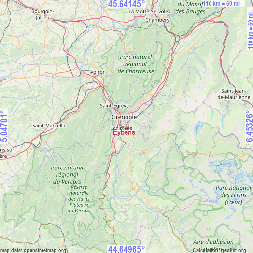
Eybens GPS coordinates[2]
45° 8' 51.756" North, 5° 45' 0.504" East
| Map corner | latitude | longitude |
|---|---|---|
| Upper-left | 45.64145°, | 5.04701° |
| Center: | 45.14771°, | 5.75014° |
| Lower-right: | 44.64965°, | 6.45326° |
| Map W x H: | 110.3×110.3 km | = 68.5×68.5mi |
| max Lat: | 51.07786° ⇑78% North |
| Eybens: | 45.14771° |
| min Lat: | ⇓22% South 41.3874° |
| min Long | Eybens | max Long |
| -5.08615° | 5.75014° | 9.52242° |
| W 84.7%⇐ | ⇒15.3% E |
Elevation
Elevation of Eybens is 320 m = 1050 ft, and this is 126.3 m = 414 ft above average elevation for this country.
| Max E: |
2333 m = 7654 ft | 17.2% |
| Eybens | 320 m 1050 ft | |
| Avg. | 193.7 m = 635 ft | |
Min E: |
-1 m = -3 ft | 82.8% |
See also: France elevation on elevation.city.
Geographical zone
Eybens is located in North temperate zone (between Tropic of Cancer and the Arctic Circle). Distance of this North polar circle is 2381.2 km =1479.6 mi to North.| Distance of | km | miles | from Eybens |
|---|---|---|---|
| North Pole | 4987.1 | 3098.8 | to North |
| Arctic Circle | 2381.2 | 1479.6 | to North |
| Tropic Cancer | 2414 | 1500 | to South |
| Equator | 5020 | 3119.3 | to South |


Nearby cities:
15 places around Eybens: (largest is in red/bold)
• Bresson
1.2 km =0.7 mi,  189°
189°
• Brié-et-Angonnes
3.7 km =2.3 mi,  134°
134°
• Champagnier
4.4 km =2.7 mi,  204°
204°
• Gières
4.7 km =2.9 mi,  40°
40°
• Grenoble
4.4 km =2.7 mi,  321°
321°
• Herbeys
3.5 km =2.2 mi,  104°
104°
• Jarrie
3.5 km =2.2 mi,  167°
167°
• Le Pont-de-Claix
4.9 km =3 mi,  236°
236°
• Poisat
1.5 km =0.9 mi,  34°
34°
• Saint-Martin-d’Hères
3.6 km =2.2 mi,  16°
16°
• Seyssinet-Pariset
5.5 km =3.4 mi,  306°
306°
• Seyssins
5.2 km =3.2 mi,  288°
288°
• Vaulnaveys-le-Haut
5.8 km =3.6 mi,  115°
115°
• Venon
5.5 km =3.4 mi,  55°
55°
• Échirolles
2.8 km =1.7 mi,  266°
266°
Sources, notices
• [Note1] Compared only with cities in France existing in our database
• [Src1] Map data: © OpenStreetMap contributors (CC-BY-SA)
• [Src2] Other city data from geonames.org with taken over terms of usage.
• [Src3] Geographical zone / Annual Mean Temperature by Robert A. Rohde @ Wikipedia
