Grenoble geodata
Grenoble (Auvergne-Rhône-Alpes) is a seat of a second-order administrative division; located in France in Europe/Paris (GMT+2) time zone. With population of 158,552 people, there are 17 cities with bigger population in this country. Compared to other cities in France, 77.7% of cities are located further ↑North; 84.5% of cities are located further ←West and 68.8% of cities have lower elevation than Grenoble. Note1
Administrative division(s):
- Level 1: Auvergne-Rhône-Alpes
- Level 2: Département de l'Isère
- Level 3: Arrondissement de Grenoble
- Level 4: Grenoble


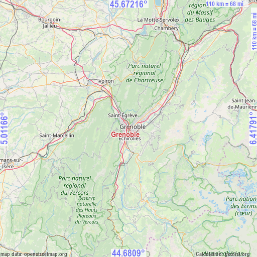
Grenoble GPS coordinates[2]
45° 10' 43.284" North, 5° 42' 53.244" East
| Map corner | latitude | longitude |
|---|---|---|
| Upper-left | 45.67216°, | 5.01166° |
| Center: | 45.17869°, | 5.71479° |
| Lower-right: | 44.6809°, | 6.41791° |
| Map W x H: | 110.2×110.2 km | = 68.5×68.5mi |
| max Lat: | 51.07786° ⇑77.7% North |
| Grenoble: | 45.17869° |
| min Lat: | ⇓22.3% South 41.3874° |
| min Long | Grenoble | max Long |
| -5.08615° | 5.71479° | 9.52242° |
| W 84.5%⇐ | ⇒15.5% E |
Elevation
Elevation of Grenoble is 213 m = 699 ft, and this is 19.3 m = 63 ft above average elevation for this country.
| Max E: |
2333 m = 7654 ft | 31.2% |
| Grenoble | 213 m 699 ft | |
| Avg. | 193.7 m = 635 ft | |
Min E: |
-1 m = -3 ft | 68.8% |
See also: Grenoble elevation on elevation.city.
Geographical zone
Grenoble is located in North temperate zone (between Tropic of Cancer and the Arctic Circle). Distance of this North polar circle is 2377.8 km =1477.5 mi to North.| Distance of | km | miles | from Grenoble |
|---|---|---|---|
| North Pole | 4983.7 | 3096.7 | to North |
| Arctic Circle | 2377.8 | 1477.5 | to North |
| Tropic Cancer | 2417.5 | 1502.2 | to South |
| Equator | 5023.4 | 3121.4 | to South |


Nearby cities:
15 places around Grenoble: (largest is in red/bold)
• Bresson
5.3 km =3.3 mi,  150°
150°
• Corenc
6 km =3.7 mi,  41°
41°
• Eybens
4.4 km =2.7 mi,  141°
141°
• Fontaine
2.6 km =1.6 mi,  306°
306°
• Gières
5.8 km =3.6 mi,  88°
88°
• La Tronche
3.8 km =2.4 mi, 40°
• Le Pont-de-Claix
6.3 km =3.9 mi,  192°
192°
• Meylan
6 km =3.7 mi,  54°
54°
• Poisat
4.2 km =2.6 mi,  122°
122°
• Saint-Martin-d’Hères
3.8 km =2.4 mi, 89°
• Saint-Martin-le-Vinoux
2.7 km =1.7 mi,  2°
2°
• Sassenage
5.5 km =3.4 mi, 312°
• Seyssinet-Pariset
1.7 km =1.1 mi,  262°
262°
• Seyssins
2.9 km =1.8 mi,  230°
230°
• Échirolles
3.6 km =2.2 mi,  180°
180°
Sources, notices
• [Note1] Compared only with cities in France existing in our database
• [Src1] Map data: © OpenStreetMap contributors (CC-BY-SA)
• [Src2] Other city data from geonames.org with taken over terms of usage.
• [Src3] Geographical zone / Annual Mean Temperature by Robert A. Rohde @ Wikipedia
