Bresson geodata
Bresson (Auvergne-Rhône-Alpes) is a populated place; located in France in Europe/Paris (GMT+2) time zone. With population of 808 people, there are 10506 cities with bigger population in this country. Compared to other cities in France, 78.1% of cities are located further ↑North; 84.7% of cities are located further ←West and 84.2% of cities have lower elevation than Bresson. Note1
Administrative division(s):
- Level 1: Auvergne-Rhône-Alpes
- Level 2: Département de l'Isère
- Level 3: Arrondissement de Grenoble
- Level 4: Bresson


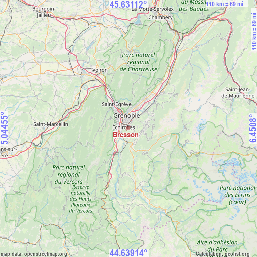
Bresson GPS coordinates[2]
45° 8' 14.244" North, 5° 44' 51.612" East
| Map corner | latitude | longitude |
|---|---|---|
| Upper-left | 45.63112°, | 5.04455° |
| Center: | 45.13729°, | 5.74767° |
| Lower-right: | 44.63914°, | 6.4508° |
| Map W x H: | 110.3×110.3 km | = 68.5×68.5mi |
| max Lat: | 51.07786° ⇑78.1% North |
| Bresson: | 45.13729° |
| min Lat: | ⇓21.9% South 41.3874° |
| min Long | Bresson | max Long |
| -5.08615° | 5.74767° | 9.52242° |
| W 84.7%⇐ | ⇒15.3% E |
Elevation
Elevation of Bresson is 337 m = 1106 ft, and this is 143.3 m = 470 ft above average elevation for this country.
| Max E: |
2333 m = 7654 ft | 15.8% |
| Bresson | 337 m 1106 ft | |
| Avg. | 193.7 m = 635 ft | |
Min E: |
-1 m = -3 ft | 84.2% |
See also: France elevation on elevation.city.
Geographical zone
Bresson is located in North temperate zone (between Tropic of Cancer and the Arctic Circle). Distance of this North polar circle is 2382.4 km =1480.4 mi to North.| Distance of | km | miles | from Bresson |
|---|---|---|---|
| North Pole | 4988.3 | 3099.6 | to North |
| Arctic Circle | 2382.4 | 1480.4 | to North |
| Tropic Cancer | 2412.9 | 1499.3 | to South |
| Equator | 5018.8 | 3118.5 | to South |


Nearby cities:
15 places around Bresson: (largest is in red/bold)
• Brié-et-Angonnes
3.2 km =2 mi,  117°
117°
• Champagnier
3.3 km =2.1 mi,  209°
209°
• Claix
6.2 km =3.9 mi,  251°
251°
• Eybens
1.2 km =0.7 mi,  9°
9°
• Gières
5.8 km =3.6 mi,  34°
34°
• Grenoble
5.3 km =3.3 mi,  330°
330°
• Herbeys
3.6 km =2.2 mi,  84°
84°
• Jarrie
2.4 km =1.5 mi,  157°
157°
• Le Pont-de-Claix
4.2 km =2.6 mi, 248°
• Poisat
2.6 km =1.6 mi,  23°
23°
• Saint-Martin-d’Hères
4.8 km =3 mi, 14°
• Seyssinet-Pariset
6.1 km =3.8 mi,  316°
316°
• Seyssins
5.5 km =3.4 mi,  300°
300°
• Vaulnaveys-le-Haut
5.6 km =3.5 mi,  103°
103°
• Échirolles
2.8 km =1.7 mi,  290°
290°
Sources, notices
• [Note1] Compared only with cities in France existing in our database
• [Src1] Map data: © OpenStreetMap contributors (CC-BY-SA)
• [Src2] Other city data from geonames.org with taken over terms of usage.
• [Src3] Geographical zone / Annual Mean Temperature by Robert A. Rohde @ Wikipedia
