Dannes geodata
Dannes (Hauts-de-France) is a populated place; located in France in Europe/Paris (GMT+2) time zone. With population of 1,286 people, there are 7096 cities with bigger population in this country. Compared to other cities in France, 98% of cities are located further ↓South; 61.5% of cities are located further →East and 89.5% of cities have higher elevation than Dannes. Note1
Administrative division(s):
- Level 1: Hauts-de-France
- Level 2: Pas-de-Calais
- Level 3: Arrondissement de Boulogne-sur-Mer
- Level 4: Dannes


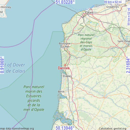
Dannes GPS coordinates[2]
50° 35' 16.764" North, 1° 36' 49.716" East
| Map corner | latitude | longitude |
|---|---|---|
| Upper-left | 51.03228°, | 0.91069° |
| Center: | 50.58799°, | 1.61381° |
| Lower-right: | 50.13946°, | 2.31694° |
| Map W x H: | 99.3×99.3 km | = 61.7×61.7mi |
| max Lat: | 51.07786° ⇑2% North |
| Dannes: | 50.58799° |
| min Lat: | ⇓98% South 41.3874° |
| min Long | Dannes | max Long |
| -5.08615° | 1.61381° | 9.52242° |
| W 38.5%⇐ | ⇒61.5% E |
Elevation
Elevation of Dannes is 31 m = 102 ft, and this is 162.7 m = 534 ft below average elevation for this country.
| Max E: |
2333 m = 7654 ft | 89.5% |
| Avg. | 193.7 m = 635 ft | |
| Dannes | 31 m = 102 ft | |
Min E: |
-1 m = -3 ft | 10.5% |
See also: France elevation on elevation.city.
Geographical zone
Dannes is located in North temperate zone (between Tropic of Cancer and the Arctic Circle). Distance of this North polar circle is 1776.3 km =1103.7 mi to North.| Distance of | km | miles | from Dannes |
|---|---|---|---|
| North Pole | 4382.2 | 2723 | to North |
| Arctic Circle | 1776.3 | 1103.7 | to North |
| Tropic Cancer | 3018.9 | 1875.9 | to South |
| Equator | 5624.9 | 3495.1 | to South |


Nearby cities:
15 places around Dannes: (largest is in red/bold)
• Bréxent-Énocq
12 km =7.5 mi,  136°
136°
• Camiers
1.8 km =1.1 mi,  181°
181°
• Carly
9.5 km =5.9 mi,  41°
41°
• Condette
7.9 km =4.9 mi,  10°
10°
• Frencq
6.8 km =4.2 mi,  116°
116°
• Hesdigneul-lès-Boulogne
8.8 km =5.5 mi,  22°
22°
• Isques
10 km =6.2 mi, 16°
• Le Touquet-Paris-Plage
7.4 km =4.6 mi,  195°
195°
• Nesles
5.2 km =3.2 mi, 35°
• Neufchâtel-Hardelot
4.1 km =2.5 mi,  29°
29°
• Saint-Léonard
11.4 km =7.1 mi,  4°
4°
• Saint-Étienne-au-Mont
10.1 km =6.3 mi, 6°
• Samer
10.9 km =6.8 mi,  59°
59°
• Équihen-Plage
10.2 km =6.3 mi,  343°
343°
• Étaples
7.5 km =4.7 mi,  169°
169°
Sources, notices
• [Note1] Compared only with cities in France existing in our database
• [Src1] Map data: © OpenStreetMap contributors (CC-BY-SA)
• [Src2] Other city data from geonames.org with taken over terms of usage.
• [Src3] Geographical zone / Annual Mean Temperature by Robert A. Rohde @ Wikipedia
