Esternay geodata
Esternay (Grand Est) is a populated place; located in France in Europe/Paris (GMT+2) time zone. With population of 1,639 people, there are 5698 cities with bigger population in this country. Compared to other cities in France, 73.9% of cities are located further ↓South; 64.8% of cities are located further ←West and 57.1% of cities have lower elevation than Esternay. Note1
Administrative division(s):
- Level 1: Grand Est
- Level 2: Marne
- Level 3: Arrondissement d'Épernay
- Level 4: Esternay


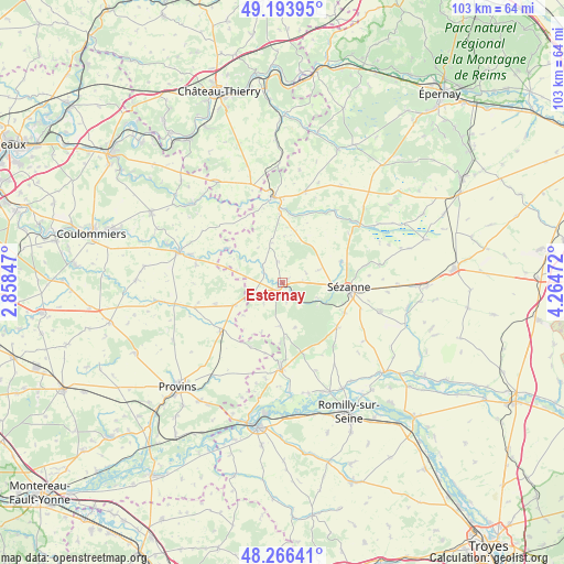
Esternay GPS coordinates[2]
48° 43' 56.352" North, 3° 33' 41.724" East
| Map corner | latitude | longitude |
|---|---|---|
| Upper-left | 49.19395°, | 2.85847° |
| Center: | 48.73232°, | 3.56159° |
| Lower-right: | 48.26641°, | 4.26472° |
| Map W x H: | 103.1×103.1 km | = 64.1×64.1mi |
| max Lat: | 51.07786° ⇑26.1% North |
| Esternay: | 48.73232° |
| min Lat: | ⇓73.9% South 41.3874° |
| min Long | Esternay | max Long |
| -5.08615° | 3.56159° | 9.52242° |
| W 64.8%⇐ | ⇒35.2% E |
Elevation
Elevation of Esternay is 158 m = 518 ft, and this is 35.7 m = 117 ft below average elevation for this country.
| Max E: |
2333 m = 7654 ft | 42.9% |
| Avg. | 193.7 m = 635 ft | |
| Esternay | 158 m = 518 ft | |
Min E: |
-1 m = -3 ft | 57.1% |
See also: France elevation on elevation.city.
Geographical zone
Esternay is located in North temperate zone (between Tropic of Cancer and the Arctic Circle). Distance of this North polar circle is 1982.6 km =1231.9 mi to North.| Distance of | km | miles | from Esternay |
|---|---|---|---|
| North Pole | 4588.5 | 2851.2 | to North |
| Arctic Circle | 1982.6 | 1231.9 | to North |
| Tropic Cancer | 2812.6 | 1747.7 | to South |
| Equator | 5418.5 | 3366.9 | to South |


Nearby cities:
15 places around Esternay: (largest is in red/bold)
• Barbonne-Fayel
12.9 km =8 mi,  130°
130°
• Conflans-sur-Seine
21.8 km =13.5 mi,  156°
156°
• Esclavolles-Lurey
21.1 km =13.1 mi, 160°
• Gaye
18.6 km =11.6 mi,  106°
106°
• La Ferté-Gaucher
19.5 km =12.1 mi,  286°
286°
• Léchelle
21.4 km =13.3 mi,  216°
216°
• Marcilly-sur-Seine
22.3 km =13.9 mi,  150°
150°
• Montmirail
15.6 km =9.7 mi,  353°
353°
• Saint-Martin-des-Champs
17.4 km =10.8 mi, 287°
• Sézanne
11.9 km =7.4 mi,  96°
96°
• Verdelot
21.4 km =13.3 mi,  317°
317°
• Viels-Maisons
21.9 km =13.6 mi,  326°
326°
• Villenauxe-la-Grande
16.6 km =10.3 mi,  182°
182°
• Villeneuve-sur-Bellot
21.6 km =13.4 mi,  311°
311°
• Villiers-Saint-Georges
14.5 km =9 mi,  231°
231°
Sources, notices
• [Note1] Compared only with cities in France existing in our database
• [Src1] Map data: © OpenStreetMap contributors (CC-BY-SA)
• [Src2] Other city data from geonames.org with taken over terms of usage.
• [Src3] Geographical zone / Annual Mean Temperature by Robert A. Rohde @ Wikipedia
