Sézanne geodata
Sézanne (Grand Est) is a populated place; located in France in Europe/Paris (GMT+2) time zone. With population of 5,748 people, there are 1720 cities with bigger population in this country. Compared to other cities in France, 73.7% of cities are located further ↓South; 65.9% of cities are located further ←West and 50.5% of cities have higher elevation than Sézanne. Note1
Administrative division(s):
- Level 1: Grand Est
- Level 2: Marne
- Level 3: Arrondissement d'Épernay
- Level 4: Sézanne


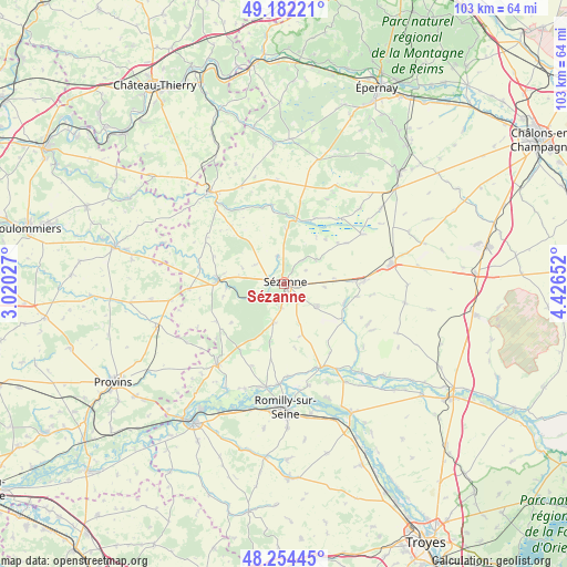
Sézanne GPS coordinates[2]
48° 43' 13.692" North, 3° 43' 24.204" East
| Map corner | latitude | longitude |
|---|---|---|
| Upper-left | 49.18221°, | 3.02027° |
| Center: | 48.72047°, | 3.72339° |
| Lower-right: | 48.25445°, | 4.42652° |
| Map W x H: | 103.2×103.2 km | = 64.1×64.1mi |
| max Lat: | 51.07786° ⇑26.3% North |
| Sézanne: | 48.72047° |
| min Lat: | ⇓73.7% South 41.3874° |
| min Long | Sézanne | max Long |
| -5.08615° | 3.72339° | 9.52242° |
| W 65.9%⇐ | ⇒34.1% E |
Elevation
Elevation of Sézanne is 130 m = 427 ft, and this is 63.7 m = 209 ft below average elevation for this country.
| Max E: |
2333 m = 7654 ft | 50.5% |
| Avg. | 193.7 m = 635 ft | |
| Sézanne | 130 m = 427 ft | |
Min E: |
-1 m = -3 ft | 49.5% |
See also: France elevation on elevation.city.
Geographical zone
Sézanne is located in North temperate zone (between Tropic of Cancer and the Arctic Circle). Distance of this North polar circle is 1984 km =1232.8 mi to North.| Distance of | km | miles | from Sézanne |
|---|---|---|---|
| North Pole | 4589.9 | 2852 | to North |
| Arctic Circle | 1984 | 1232.8 | to North |
| Tropic Cancer | 2811.3 | 1746.9 | to South |
| Equator | 5417.2 | 3366.1 | to South |


Nearby cities:
15 places around Sézanne: (largest is in red/bold)
• Anglure
16.4 km =10.2 mi,  155°
155°
• Barbonne-Fayel
7.5 km =4.7 mi,  196°
196°
• Clesles
22.3 km =13.9 mi, 158°
• Conflans-sur-Seine
19 km =11.8 mi,  189°
189°
• Connantre
14.7 km =9.1 mi,  87°
87°
• Esclavolles-Lurey
19.3 km =12 mi, 194°
• Esternay
11.9 km =7.4 mi,  276°
276°
• Fère-Champenoise
20 km =12.4 mi,  79°
79°
• Gaye
7.2 km =4.5 mi,  124°
124°
• Marcilly-sur-Seine
18.2 km =11.3 mi,  183°
183°
• Montmirail
21.7 km =13.5 mi,  321°
321°
• Pleurs
11.4 km =7.1 mi,  106°
106°
• Romilly-sur-Seine
23.3 km =14.5 mi, 179°
• Saint-Just-Sauvage
19 km =11.8 mi,  166°
166°
• Villenauxe-la-Grande
19.9 km =12.4 mi,  219°
219°
Sources, notices
• [Note1] Compared only with cities in France existing in our database
• [Src1] Map data: © OpenStreetMap contributors (CC-BY-SA)
• [Src2] Other city data from geonames.org with taken over terms of usage.
• [Src3] Geographical zone / Annual Mean Temperature by Robert A. Rohde @ Wikipedia
