Espelette geodata
Espelette (Nouvelle-Aquitaine) is a populated place; located in France in Europe/Paris (GMT+2) time zone. With population of 2,032 people, there are 4722 cities with bigger population in this country. Compared to other cities in France, 95% of cities are located further ↑North; 91.9% of cities are located further →East and 70.5% of cities have higher elevation than Espelette. Note1
Administrative division(s):
- Level 1: Nouvelle-Aquitaine
- Level 2: Département des Pyrénées-Atlantiques
- Level 3: Arrondissement de Bayonne
- Level 4: Espelette


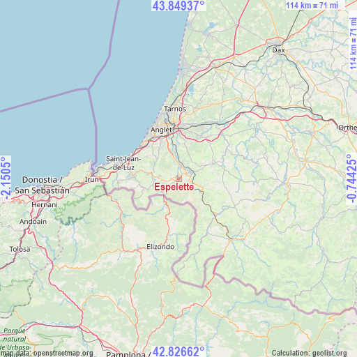
Espelette GPS coordinates[2]
43° 20' 24.54" North, 1° 26' 50.532" West
| Map corner | latitude | longitude |
|---|---|---|
| Upper-left | 43.84937°, | -2.1505° |
| Center: | 43.34015°, | -1.44737° |
| Lower-right: | 42.82662°, | -0.74425° |
| Map W x H: | 113.7×113.7 km | = 70.6×70.6mi |
| max Lat: | 51.07786° ⇑95% North |
| Espelette: | 43.34015° |
| min Lat: | ⇓5% South 41.3874° |
| min Long | Espelette | max Long |
| -5.08615° | -1.44737° | 9.52242° |
| W 8.1%⇐ | ⇒91.9% E |
Elevation
Elevation of Espelette is 77 m = 253 ft, and this is 116.7 m = 383 ft below average elevation for this country.
| Max E: |
2333 m = 7654 ft | 70.5% |
| Avg. | 193.7 m = 635 ft | |
| Espelette | 77 m = 253 ft | |
Min E: |
-1 m = -3 ft | 29.5% |
See also: France elevation on elevation.city.
Geographical zone
Espelette is located in North temperate zone (between Tropic of Cancer and the Arctic Circle). Distance of this Northern Tropic circle is 2213.1 km =1375.2 mi to South.| Distance of | km | miles | from Espelette |
|---|---|---|---|
| North Pole | 5188.1 | 3223.7 | to North |
| Arctic Circle | 2582.2 | 1604.5 | to North |
| Tropic Cancer | 2213.1 | 1375.2 | to South |
| Equator | 4819 | 2994.4 | to South |


Nearby cities:
15 places around Espelette: (largest is in red/bold)
• Ainhoa
6.2 km =3.9 mi,  223°
223°
• Arcangues
11.8 km =7.3 mi,  329°
329°
• Bidarray
11.6 km =7.2 mi,  135°
135°
• Cambo-les-Bains
4.3 km =2.7 mi,  61°
61°
• Halsou
4.4 km =2.7 mi,  24°
24°
• Itxassou
3.6 km =2.2 mi,  110°
110°
• Jatxou
5.5 km =3.4 mi,  13°
13°
• Larressore
3.1 km =1.9 mi, 11°
• Louhossoa
8.2 km =5.1 mi, 108°
• Macaye
10.3 km =6.4 mi,  95°
95°
• Saint-Pée-sur-Nivelle
8.5 km =5.3 mi,  281°
281°
• Sare
11.2 km =7 mi,  254°
254°
• Souraïde
2.3 km =1.4 mi,  273°
273°
• Ustaritz
6.3 km =3.9 mi,  353°
353°
• Villefranque
10.7 km =6.6 mi,  357°
357°
Sources, notices
• [Note1] Compared only with cities in France existing in our database
• [Src1] Map data: © OpenStreetMap contributors (CC-BY-SA)
• [Src2] Other city data from geonames.org with taken over terms of usage.
• [Src3] Geographical zone / Annual Mean Temperature by Robert A. Rohde @ Wikipedia
