Ustaritz geodata
Ustaritz (Nouvelle-Aquitaine) is a populated place; located in France in Europe/Paris (GMT+2) time zone. With population of 5,662 people, there are 1753 cities with bigger population in this country. Compared to other cities in France, 94.3% of cities are located further ↑North; 91.9% of cities are located further →East and 94.4% of cities have higher elevation than Ustaritz. Note1
Administrative division(s):
- Level 1: Nouvelle-Aquitaine
- Level 2: Département des Pyrénées-Atlantiques
- Level 3: Arrondissement de Bayonne
- Level 4: Ustaritz


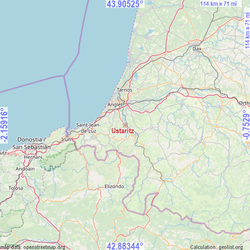
Ustaritz GPS coordinates[2]
43° 23' 47.4" North, 1° 27' 21.708" West
| Map corner | latitude | longitude |
|---|---|---|
| Upper-left | 43.90525°, | -2.15916° |
| Center: | 43.3965°, | -1.45603° |
| Lower-right: | 42.88344°, | -0.7529° |
| Map W x H: | 113.6×113.6 km | = 70.6×70.6mi |
| max Lat: | 51.07786° ⇑94.3% North |
| Ustaritz: | 43.3965° |
| min Lat: | ⇓5.7% South 41.3874° |
| min Long | Ustaritz | max Long |
| -5.08615° | -1.45603° | 9.52242° |
| W 8.1%⇐ | ⇒91.9% E |
Elevation
Elevation of Ustaritz is 19 m = 62 ft, and this is 174.7 m = 573 ft below average elevation for this country.
| Max E: |
2333 m = 7654 ft | 94.4% |
| Avg. | 193.7 m = 635 ft | |
| Ustaritz | 19 m = 62 ft | |
Min E: |
-1 m = -3 ft | 5.6% |
See also: France elevation on elevation.city.
Geographical zone
Ustaritz is located in North temperate zone (between Tropic of Cancer and the Arctic Circle). Distance of this Northern Tropic circle is 2219.3 km =1379 mi to South.| Distance of | km | miles | from Ustaritz |
|---|---|---|---|
| North Pole | 5181.8 | 3219.8 | to North |
| Arctic Circle | 2575.9 | 1600.6 | to North |
| Tropic Cancer | 2219.3 | 1379 | to South |
| Equator | 4825.2 | 2998.2 | to South |


Nearby cities:
15 places around Ustaritz: (largest is in red/bold)
• Ahetze
9.4 km =5.8 mi,  275°
275°
• Anglet
10 km =6.2 mi,  332°
332°
• Arbonne
8.7 km =5.4 mi,  297°
297°
• Arcangues
6.6 km =4.1 mi,  305°
305°
• Bassussarry
7.1 km =4.4 mi,  316°
316°
• Cambo-les-Bains
6.1 km =3.8 mi,  133°
133°
• Espelette
6.3 km =3.9 mi,  173°
173°
• Halsou
3.4 km =2.1 mi, 131°
• Itxassou
8.5 km =5.3 mi,  151°
151°
• Jatxou
2.2 km =1.4 mi,  114°
114°
• Larressore
3.4 km =2.1 mi,  157°
157°
• Mouguerre
8.5 km =5.3 mi,  21°
21°
• Saint-Pée-sur-Nivelle
8.9 km =5.5 mi,  239°
239°
• Souraïde
6.3 km =3.9 mi,  194°
194°
• Villefranque
4.4 km =2.7 mi,  2°
2°
Sources, notices
• [Note1] Compared only with cities in France existing in our database
• [Src1] Map data: © OpenStreetMap contributors (CC-BY-SA)
• [Src2] Other city data from geonames.org with taken over terms of usage.
• [Src3] Geographical zone / Annual Mean Temperature by Robert A. Rohde @ Wikipedia
