Itxassou geodata
Itxassou (Nouvelle-Aquitaine) is a populated place; located in France in Europe/Paris (GMT+2) time zone. With population of 1,918 people, there are 4993 cities with bigger population in this country. Compared to other cities in France, 95.2% of cities are located further ↑North; 91.6% of cities are located further →East and 71% of cities have higher elevation than Itxassou. Note1
Administrative division(s):
- Level 1: Nouvelle-Aquitaine
- Level 2: Département des Pyrénées-Atlantiques
- Level 3: Arrondissement de Bayonne
- Level 4: Itxassou


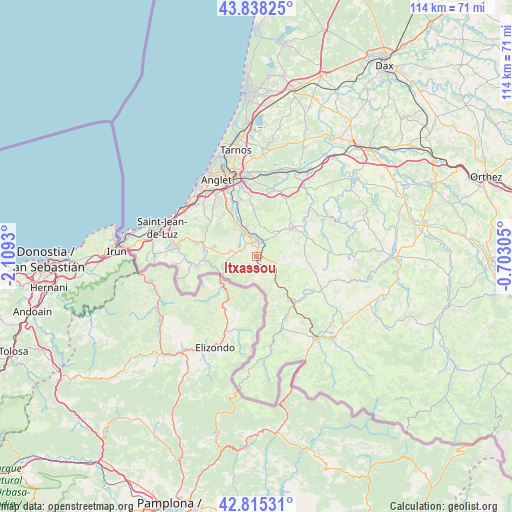
Itxassou GPS coordinates[2]
43° 19' 44.148" North, 1° 24' 22.212" West
| Map corner | latitude | longitude |
|---|---|---|
| Upper-left | 43.83825°, | -2.1093° |
| Center: | 43.32893°, | -1.40617° |
| Lower-right: | 42.81531°, | -0.70305° |
| Map W x H: | 113.7×113.7 km | = 70.6×70.6mi |
| max Lat: | 51.07786° ⇑95.2% North |
| Itxassou: | 43.32893° |
| min Lat: | ⇓4.8% South 41.3874° |
| min Long | Itxassou | max Long |
| -5.08615° | -1.40617° | 9.52242° |
| W 8.4%⇐ | ⇒91.6% E |
Elevation
Elevation of Itxassou is 76 m = 249 ft, and this is 117.7 m = 386 ft below average elevation for this country.
| Max E: |
2333 m = 7654 ft | 71% |
| Avg. | 193.7 m = 635 ft | |
| Itxassou | 76 m = 249 ft | |
Min E: |
-1 m = -3 ft | 29% |
See also: France elevation on elevation.city.
Geographical zone
Itxassou is located in North temperate zone (between Tropic of Cancer and the Arctic Circle). Distance of this Northern Tropic circle is 2211.8 km =1374.3 mi to South.| Distance of | km | miles | from Itxassou |
|---|---|---|---|
| North Pole | 5189.3 | 3224.5 | to North |
| Arctic Circle | 2583.4 | 1605.2 | to North |
| Tropic Cancer | 2211.8 | 1374.3 | to South |
| Equator | 4817.7 | 2993.6 | to South |


Nearby cities:
15 places around Itxassou: (largest is in red/bold)
• Ainhoa
8.2 km =5.1 mi,  247°
247°
• Bidarray
8.5 km =5.3 mi,  145°
145°
• Cambo-les-Bains
3.3 km =2.1 mi,  7°
7°
• Espelette
3.6 km =2.2 mi,  290°
290°
• Halsou
5.5 km =3.4 mi,  344°
344°
• Hasparren
10.2 km =6.3 mi,  53°
53°
• Jatxou
6.9 km =4.3 mi, 342°
• Larressore
5.1 km =3.2 mi,  327°
327°
• Louhossoa
4.7 km =2.9 mi,  107°
107°
• Macaye
7 km =4.3 mi,  87°
87°
• Mendionde
8.7 km =5.4 mi,  82°
82°
• Saint-Pée-sur-Nivelle
12 km =7.5 mi,  284°
284°
• Souraïde
5.8 km =3.6 mi, 284°
• Ustaritz
8.5 km =5.3 mi, 331°
• Villefranque
12.5 km =7.8 mi, 342°
Sources, notices
• [Note1] Compared only with cities in France existing in our database
• [Src1] Map data: © OpenStreetMap contributors (CC-BY-SA)
• [Src2] Other city data from geonames.org with taken over terms of usage.
• [Src3] Geographical zone / Annual Mean Temperature by Robert A. Rohde @ Wikipedia
