Erdeven geodata
Erdeven (Brittany) is a populated place; located in France in Europe/Paris (GMT+2) time zone. With population of 2,725 people, there are 3592 cities with bigger population in this country. Compared to other cities in France, 53.3% of cities are located further ↓South; 97.6% of cities are located further →East and 95% of cities have higher elevation than Erdeven. Note1
Administrative division(s):
- Level 1: Brittany
- Level 2: Morbihan
- Level 3: Arrondissement de Lorient
- Level 4: Erdeven


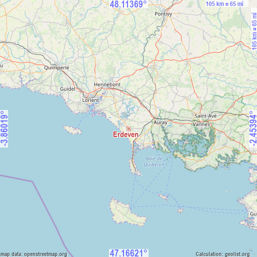
Erdeven GPS coordinates[2]
47° 38' 31.56" North, 3° 9' 25.416" West
| Map corner | latitude | longitude |
|---|---|---|
| Upper-left | 48.11369°, | -3.86019° |
| Center: | 47.6421°, | -3.15706° |
| Lower-right: | 47.16621°, | -2.45394° |
| Map W x H: | 105.3×105.3 km | = 65.4×65.4mi |
| max Lat: | 51.07786° ⇑46.7% North |
| Erdeven: | 47.6421° |
| min Lat: | ⇓53.3% South 41.3874° |
| min Long | Erdeven | max Long |
| -5.08615° | -3.15706° | 9.52242° |
| W 2.4%⇐ | ⇒97.6% E |
Elevation
Elevation of Erdeven is 17 m = 56 ft, and this is 176.7 m = 580 ft below average elevation for this country.
| Max E: |
2333 m = 7654 ft | 95% |
| Avg. | 193.7 m = 635 ft | |
| Erdeven | 17 m = 56 ft | |
Min E: |
-1 m = -3 ft | 5% |
See also: France elevation on elevation.city.
Geographical zone
Erdeven is located in North temperate zone (between Tropic of Cancer and the Arctic Circle). Distance of this North polar circle is 2103.9 km =1307.3 mi to North.| Distance of | km | miles | from Erdeven |
|---|---|---|---|
| North Pole | 4709.8 | 2926.5 | to North |
| Arctic Circle | 2103.9 | 1307.3 | to North |
| Tropic Cancer | 2691.4 | 1672.4 | to South |
| Equator | 5297.3 | 3291.6 | to South |


Nearby cities:
15 places around Erdeven: (largest is in red/bold)
• Auray
12.8 km =8 mi,  75°
75°
• Belz
3.8 km =2.4 mi,  347°
347°
• Carnac
8.8 km =5.5 mi,  138°
138°
• Crach
12 km =7.5 mi,  103°
103°
• La Trinité-sur-Mer
11.3 km =7 mi,  122°
122°
• Landaul
13.2 km =8.2 mi,  27°
27°
• Locoal-Mendon
7.9 km =4.9 mi, 27°
• Merlevenez
11.8 km =7.3 mi,  332°
332°
• Nostang
12.1 km =7.5 mi, 349°
• Ploemel
6.6 km =4.1 mi, 80°
• Plouharnel
5.9 km =3.7 mi,  145°
145°
• Saint-Philibert
13.2 km =8.2 mi, 116°
• Saint-Pierre-Quiberon
13.7 km =8.5 mi,  171°
171°
• Sainte-Hélène
9.3 km =5.8 mi,  338°
338°
• Étel
3.6 km =2.2 mi,  295°
295°
Sources, notices
• [Note1] Compared only with cities in France existing in our database
• [Src1] Map data: © OpenStreetMap contributors (CC-BY-SA)
• [Src2] Other city data from geonames.org with taken over terms of usage.
• [Src3] Geographical zone / Annual Mean Temperature by Robert A. Rohde @ Wikipedia
