Ennezat geodata
Ennezat (Auvergne-Rhône-Alpes) is a populated place; located in France in Europe/Paris (GMT+2) time zone. With population of 2,194 people, there are 4380 cities with bigger population in this country. Compared to other cities in France, 67.6% of cities are located further ↑North; 60.9% of cities are located further ←West and 82.8% of cities have lower elevation than Ennezat. Note1
Administrative division(s):
- Level 1: Auvergne-Rhône-Alpes
- Level 2: Département du Puy-de-Dôme
- Level 3: Arrondissement de Riom
- Level 4: Ennezat


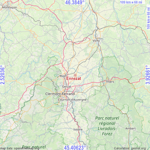
Ennezat GPS coordinates[2]
45° 53' 51.792" North, 3° 13' 24.528" East
| Map corner | latitude | longitude |
|---|---|---|
| Upper-left | 46.3849°, | 2.52036° |
| Center: | 45.89772°, | 3.22348° |
| Lower-right: | 45.40623°, | 3.92661° |
| Map W x H: | 108.8×108.8 km | = 67.6×67.6mi |
| max Lat: | 51.07786° ⇑67.6% North |
| Ennezat: | 45.89772° |
| min Lat: | ⇓32.4% South 41.3874° |
| min Long | Ennezat | max Long |
| -5.08615° | 3.22348° | 9.52242° |
| W 60.9%⇐ | ⇒39.1% E |
Elevation
Elevation of Ennezat is 320 m = 1050 ft, and this is 126.3 m = 414 ft above average elevation for this country.
| Max E: |
2333 m = 7654 ft | 17.2% |
| Ennezat | 320 m 1050 ft | |
| Avg. | 193.7 m = 635 ft | |
Min E: |
-1 m = -3 ft | 82.8% |
See also: France elevation on elevation.city.
Geographical zone
Ennezat is located in North temperate zone (between Tropic of Cancer and the Arctic Circle). Distance of this North polar circle is 2297.8 km =1427.8 mi to North.| Distance of | km | miles | from Ennezat |
|---|---|---|---|
| North Pole | 4903.7 | 3047 | to North |
| Arctic Circle | 2297.8 | 1427.8 | to North |
| Tropic Cancer | 2497.4 | 1551.8 | to South |
| Equator | 5103.3 | 3171 | to South |


Nearby cities:
15 places around Ennezat: (largest is in red/bold)
• Cellule
8.5 km =5.3 mi,  310°
310°
• Chappes
3.3 km =2.1 mi,  183°
183°
• Culhat
9.6 km =6 mi,  114°
114°
• Entraigues
3 km =1.9 mi, 106°
• Joze
7.2 km =4.5 mi,  122°
122°
• Les Martres-d'Artière
7.9 km =4.9 mi,  154°
154°
• Lussat
6.6 km =4.1 mi,  185°
185°
• Maringues
8.7 km =5.4 mi,  72°
72°
• Martres-sur-Morge
4.4 km =2.7 mi,  356°
356°
• Ménétrol
8.2 km =5.1 mi,  249°
249°
• Riom
8.6 km =5.3 mi,  266°
266°
• Saint-Beauzire
6.3 km =3.9 mi,  212°
212°
• Saint-Bonnet-près-Riom
9.3 km =5.8 mi,  292°
292°
• Saint-Ignat
4.9 km =3 mi,  54°
54°
• Thuret
8.4 km =5.2 mi,  19°
19°
Sources, notices
• [Note1] Compared only with cities in France existing in our database
• [Src1] Map data: © OpenStreetMap contributors (CC-BY-SA)
• [Src2] Other city data from geonames.org with taken over terms of usage.
• [Src3] Geographical zone / Annual Mean Temperature by Robert A. Rohde @ Wikipedia
