Chappes geodata
Chappes (Auvergne-Rhône-Alpes) is a populated place; located in France in Europe/Paris (GMT+2) time zone. With population of 1,398 people, there are 6613 cities with bigger population in this country. Compared to other cities in France, 68.2% of cities are located further ↑North; 60.9% of cities are located further ←West and 82.2% of cities have lower elevation than Chappes. Note1
Administrative division(s):
- Level 1: Auvergne-Rhône-Alpes
- Level 2: Département du Puy-de-Dôme
- Level 3: Arrondissement de Riom
- Level 4: Chappes


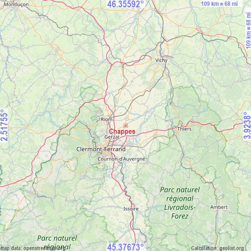
Chappes GPS coordinates[2]
45° 52' 6.528" North, 3° 13' 14.448" East
| Map corner | latitude | longitude |
|---|---|---|
| Upper-left | 46.35592°, | 2.51755° |
| Center: | 45.86848°, | 3.22068° |
| Lower-right: | 45.37673°, | 3.9238° |
| Map W x H: | 108.9×108.9 km | = 67.7×67.7mi |
| max Lat: | 51.07786° ⇑68.2% North |
| Chappes: | 45.86848° |
| min Lat: | ⇓31.8% South 41.3874° |
| min Long | Chappes | max Long |
| -5.08615° | 3.22068° | 9.52242° |
| W 60.9%⇐ | ⇒39.1% E |
Elevation
Elevation of Chappes is 312 m = 1024 ft, and this is 118.3 m = 388 ft above average elevation for this country.
| Max E: |
2333 m = 7654 ft | 17.8% |
| Chappes | 312 m 1024 ft | |
| Avg. | 193.7 m = 635 ft | |
Min E: |
-1 m = -3 ft | 82.2% |
See also: France elevation on elevation.city.
Geographical zone
Chappes is located in North temperate zone (between Tropic of Cancer and the Arctic Circle). Distance of this North polar circle is 2301.1 km =1429.8 mi to North.| Distance of | km | miles | from Chappes |
|---|---|---|---|
| North Pole | 4907 | 3049.1 | to North |
| Arctic Circle | 2301.1 | 1429.8 | to North |
| Tropic Cancer | 2494.2 | 1549.8 | to South |
| Equator | 5100.1 | 3169.1 | to South |


Nearby cities:
15 places around Chappes: (largest is in red/bold)
• Aulnat
8.7 km =5.4 mi,  208°
208°
• Culhat
9 km =5.6 mi,  94°
94°
• Ennezat
3.3 km =2.1 mi,  3°
3°
• Entraigues
3.9 km =2.4 mi,  52°
52°
• Gerzat
7.6 km =4.7 mi,  231°
231°
• Joze
6.3 km =3.9 mi,  95°
95°
• Les Martres-d'Artière
5.3 km =3.3 mi,  137°
137°
• Lussat
3.3 km =2.1 mi,  186°
186°
• Malintrat
6.5 km =4 mi,  204°
204°
• Martres-sur-Morge
7.6 km =4.7 mi,  359°
359°
• Ménétrol
7.5 km =4.7 mi,  272°
272°
• Pont-du-Château
8.1 km =5 mi,  164°
164°
• Riom
8.8 km =5.5 mi,  288°
288°
• Saint-Beauzire
3.8 km =2.4 mi,  236°
236°
• Saint-Ignat
7.4 km =4.6 mi,  34°
34°
Sources, notices
• [Note1] Compared only with cities in France existing in our database
• [Src1] Map data: © OpenStreetMap contributors (CC-BY-SA)
• [Src2] Other city data from geonames.org with taken over terms of usage.
• [Src3] Geographical zone / Annual Mean Temperature by Robert A. Rohde @ Wikipedia
