Thuret geodata
Thuret (Auvergne-Rhône-Alpes) is a populated place; located in France in Europe/Paris (GMT+2) time zone. With population of 702 people, there are 11777 cities with bigger population in this country. Compared to other cities in France, 66.6% of cities are located further ↑North; 61.5% of cities are located further ←West and 82.2% of cities have lower elevation than Thuret. Note1
Administrative division(s):
- Level 1: Auvergne-Rhône-Alpes
- Level 2: Département du Puy-de-Dôme
- Level 3: Arrondissement de Riom
- Level 4: Thuret


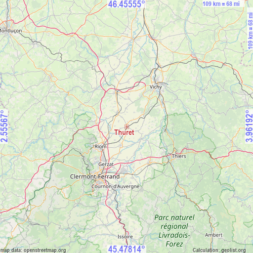
Thuret GPS coordinates[2]
45° 58' 8.4" North, 3° 15' 31.644" East
| Map corner | latitude | longitude |
|---|---|---|
| Upper-left | 46.45555°, | 2.55567° |
| Center: | 45.969°, | 3.25879° |
| Lower-right: | 45.47814°, | 3.96192° |
| Map W x H: | 108.7×108.7 km | = 67.5×67.5mi |
| max Lat: | 51.07786° ⇑66.6% North |
| Thuret: | 45.969° |
| min Lat: | ⇓33.4% South 41.3874° |
| min Long | Thuret | max Long |
| -5.08615° | 3.25879° | 9.52242° |
| W 61.5%⇐ | ⇒38.5% E |
Elevation
Elevation of Thuret is 312 m = 1024 ft, and this is 118.3 m = 388 ft above average elevation for this country.
| Max E: |
2333 m = 7654 ft | 17.8% |
| Thuret | 312 m 1024 ft | |
| Avg. | 193.7 m = 635 ft | |
Min E: |
-1 m = -3 ft | 82.2% |
See also: France elevation on elevation.city.
Geographical zone
Thuret is located in North temperate zone (between Tropic of Cancer and the Arctic Circle). Distance of this North polar circle is 2289.9 km =1422.9 mi to North.| Distance of | km | miles | from Thuret |
|---|---|---|---|
| North Pole | 4895.8 | 3042.1 | to North |
| Arctic Circle | 2289.9 | 1422.9 | to North |
| Tropic Cancer | 2505.4 | 1556.8 | to South |
| Equator | 5111.3 | 3176 | to South |


Nearby cities:
15 places around Thuret: (largest is in red/bold)
• Aigueperse
7.4 km =4.6 mi,  323°
323°
• Artonne
9.7 km =6 mi,  293°
293°
• Beauregard-Vendon
11.5 km =7.1 mi,  264°
264°
• Cellule
9.5 km =5.9 mi, 255°
• Chappes
11.6 km =7.2 mi,  194°
194°
• Crevant-Laveine
10.8 km =6.7 mi,  123°
123°
• Davayat
11.9 km =7.4 mi, 258°
• Effiat
7.9 km =4.9 mi,  358°
358°
• Ennezat
8.4 km =5.2 mi,  199°
199°
• Entraigues
8.8 km =5.5 mi,  178°
178°
• Luzillat
10.5 km =6.5 mi,  103°
103°
• Maringues
7.6 km =4.7 mi,  133°
133°
• Martres-sur-Morge
4.7 km =2.9 mi,  219°
219°
• Randan
9.2 km =5.7 mi,  53°
53°
• Saint-Ignat
5.2 km =3.2 mi,  166°
166°
Sources, notices
• [Note1] Compared only with cities in France existing in our database
• [Src1] Map data: © OpenStreetMap contributors (CC-BY-SA)
• [Src2] Other city data from geonames.org with taken over terms of usage.
• [Src3] Geographical zone / Annual Mean Temperature by Robert A. Rohde @ Wikipedia
