Saint-Ignat geodata
Saint-Ignat (Auvergne-Rhône-Alpes) is a populated place; located in France in Europe/Paris (GMT+2) time zone. With population of 684 people, there are 12023 cities with bigger population in this country. Compared to other cities in France, 67.3% of cities are located further ↑North; 61.7% of cities are located further ←West and 81.9% of cities have lower elevation than Saint-Ignat. Note1
Administrative division(s):
- Level 1: Auvergne-Rhône-Alpes
- Level 2: Département du Puy-de-Dôme
- Level 3: Arrondissement de Riom
- Level 4: Saint-Ignat


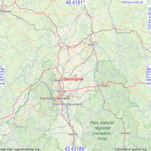
Saint-Ignat GPS coordinates[2]
45° 55' 23.34" North, 3° 16' 28.056" East
| Map corner | latitude | longitude |
|---|---|---|
| Upper-left | 46.4101°, | 2.57134° |
| Center: | 45.92315°, | 3.27446° |
| Lower-right: | 45.43188°, | 3.97759° |
| Map W x H: | 108.8×108.8 km | = 67.6×67.6mi |
| max Lat: | 51.07786° ⇑67.3% North |
| Saint-Ignat: | 45.92315° |
| min Lat: | ⇓32.7% South 41.3874° |
| min Long | Saint-Ignat | max Long |
| -5.08615° | 3.27446° | 9.52242° |
| W 61.7%⇐ | ⇒38.3% E |
Elevation
Elevation of Saint-Ignat is 310 m = 1017 ft, and this is 116.3 m = 382 ft above average elevation for this country.
| Max E: |
2333 m = 7654 ft | 18.1% |
| Saint-Ignat | 310 m 1017 ft | |
| Avg. | 193.7 m = 635 ft | |
Min E: |
-1 m = -3 ft | 81.9% |
See also: France elevation on elevation.city.
Geographical zone
Saint-Ignat is located in North temperate zone (between Tropic of Cancer and the Arctic Circle). Distance of this North polar circle is 2295 km =1426 mi to North.| Distance of | km | miles | from Saint-Ignat |
|---|---|---|---|
| North Pole | 4900.9 | 3045.3 | to North |
| Arctic Circle | 2295 | 1426 | to North |
| Tropic Cancer | 2500.3 | 1553.6 | to South |
| Equator | 5106.2 | 3172.8 | to South |


Nearby cities:
15 places around Saint-Ignat: (largest is in red/bold)
• Cellule
10.7 km =6.6 mi,  284°
284°
• Chappes
7.4 km =4.6 mi,  214°
214°
• Crevant-Laveine
7.8 km =4.8 mi,  96°
96°
• Culhat
8.3 km =5.2 mi,  144°
144°
• Ennezat
4.9 km =3 mi,  234°
234°
• Entraigues
3.8 km =2.4 mi,  195°
195°
• Joze
7 km =4.3 mi,  162°
162°
• Les Martres-d'Artière
10 km =6.2 mi,  183°
183°
• Lussat
10.5 km =6.5 mi, 205°
• Luzillat
9.3 km =5.8 mi,  73°
73°
• Maringues
4.3 km =2.7 mi,  92°
92°
• Martres-sur-Morge
4.5 km =2.8 mi,  289°
289°
• Randan
12.2 km =7.6 mi,  30°
30°
• Saint-Beauzire
11 km =6.8 mi,  221°
221°
• Thuret
5.2 km =3.2 mi,  346°
346°
Sources, notices
• [Note1] Compared only with cities in France existing in our database
• [Src1] Map data: © OpenStreetMap contributors (CC-BY-SA)
• [Src2] Other city data from geonames.org with taken over terms of usage.
• [Src3] Geographical zone / Annual Mean Temperature by Robert A. Rohde @ Wikipedia
