Életot geodata
Életot (Normandy) is a populated place; located in France in Europe/Paris (GMT+2) time zone. With population of 549 people, there are 14229 cities with bigger population in this country. Compared to other cities in France, 92.2% of cities are located further ↓South; 73.9% of cities are located further →East and 58.7% of cities have higher elevation than Életot. Note1
Administrative division(s):
- Level 1: Normandy
- Level 2: Seine-Maritime
- Level 3: Arrondissement du Havre
- Level 4: Életot


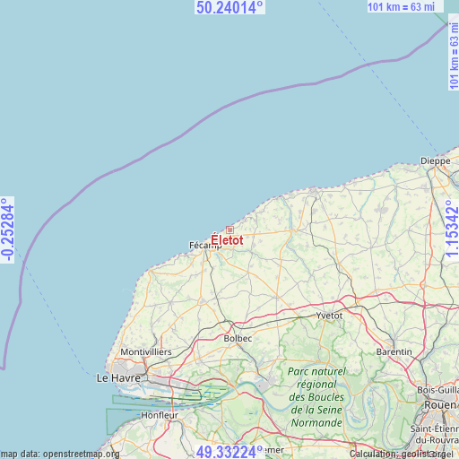
Életot GPS coordinates[2]
49° 47' 17.952" North, 0° 27' 1.044" East
| Map corner | latitude | longitude |
|---|---|---|
| Upper-left | 50.24014°, | -0.25284° |
| Center: | 49.78832°, | 0.45029° |
| Lower-right: | 49.33224°, | 1.15342° |
| Map W x H: | 100.9×100.9 km | = 62.7×62.7mi |
| max Lat: | 51.07786° ⇑7.8% North |
| Életot: | 49.78832° |
| min Lat: | ⇓92.2% South 41.3874° |
| min Long | Életot | max Long |
| -5.08615° | 0.45029° | 9.52242° |
| W 26.1%⇐ | ⇒73.9% E |
Elevation
Elevation of Életot is 106 m = 348 ft, and this is 87.7 m = 288 ft below average elevation for this country.
| Max E: |
2333 m = 7654 ft | 58.7% |
| Avg. | 193.7 m = 635 ft | |
| Életot | 106 m = 348 ft | |
Min E: |
-1 m = -3 ft | 41.3% |
See also: France elevation on elevation.city.
Geographical zone
Életot is located in North temperate zone (between Tropic of Cancer and the Arctic Circle). Distance of this North polar circle is 1865.2 km =1159 mi to North.| Distance of | km | miles | from Életot |
|---|---|---|---|
| North Pole | 4471.1 | 2778.2 | to North |
| Arctic Circle | 1865.2 | 1159 | to North |
| Tropic Cancer | 2930 | 1820.6 | to South |
| Equator | 5535.9 | 3439.8 | to South |


Nearby cities:
15 places around Életot: (largest is in red/bold)
• Angerville-la-Martel
4.8 km =3 mi,  128°
128°
• Bec-de-Mortagne
9.7 km =6 mi,  180°
180°
• Colleville
4.4 km =2.7 mi,  172°
172°
• Froberville
11.1 km =6.9 mi,  228°
228°
• Fécamp
6.4 km =4 mi,  238°
238°
• Saint-Léonard
8.3 km =5.2 mi, 232°
• Saint-Martin-aux-Buneaux
8.6 km =5.3 mi,  62°
62°
• Saint-Pierre-en-Port
3.9 km =2.4 mi, 60°
• Sainte-Hélène-Bondeville
1.7 km =1.1 mi,  153°
153°
• Sassetot-le-Mauconduit
5.8 km =3.6 mi,  71°
71°
• Senneville-sur-Fécamp
3.1 km =1.9 mi, 233°
• Tourville-les-Ifs
9 km =5.6 mi,  203°
203°
• Toussaint
5.9 km =3.7 mi, 198°
• Valmont
6.7 km =4.2 mi,  137°
137°
• Épreville
10.9 km =6.8 mi,  213°
213°
Sources, notices
• [Note1] Compared only with cities in France existing in our database
• [Src1] Map data: © OpenStreetMap contributors (CC-BY-SA)
• [Src2] Other city data from geonames.org with taken over terms of usage.
• [Src3] Geographical zone / Annual Mean Temperature by Robert A. Rohde @ Wikipedia
