Angerville-la-Martel geodata
Angerville-la-Martel (Normandy) is a populated place; located in France in Europe/Paris (GMT+2) time zone. With population of 689 people, there are 11953 cities with bigger population in this country. Compared to other cities in France, 92% of cities are located further ↓South; 73.4% of cities are located further →East and 53.8% of cities have higher elevation than Angerville-la-Martel. Note1
Administrative division(s):
- Level 1: Normandy
- Level 2: Seine-Maritime
- Level 3: Arrondissement du Havre
- Level 4: Angerville-la-Martel


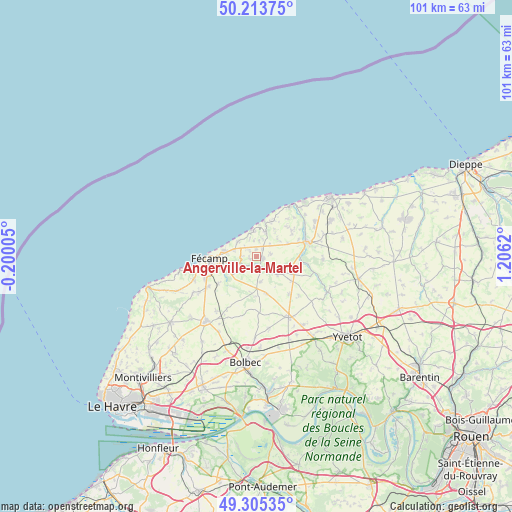
Angerville-la-Martel GPS coordinates[2]
49° 45' 42.048" North, 0° 30' 11.052" East
| Map corner | latitude | longitude |
|---|---|---|
| Upper-left | 50.21375°, | -0.20005° |
| Center: | 49.76168°, | 0.50307° |
| Lower-right: | 49.30535°, | 1.2062° |
| Map W x H: | 101×101 km | = 62.8×62.8mi |
| max Lat: | 51.07786° ⇑8% North |
| Angerville-la-Martel: | 49.76168° |
| min Lat: | ⇓92% South 41.3874° |
| min Long | Angerville-la-M | max Long |
| -5.08615° | 0.50307° | 9.52242° |
| W 26.6%⇐ | ⇒73.4% E |
Elevation
Elevation of Angerville-la-Martel is 120 m = 394 ft, and this is 73.7 m = 242 ft below average elevation for this country.
| Max E: |
2333 m = 7654 ft | 53.8% |
| Avg. | 193.7 m = 635 ft | |
| Angerville-la-Martel | 120 m = 394 ft | |
Min E: |
-1 m = -3 ft | 46.2% |
See also: France elevation on elevation.city.
Geographical zone
Angerville-la-Martel is located in North temperate zone (between Tropic of Cancer and the Arctic Circle). Distance of this North polar circle is 1868.2 km =1160.8 mi to North.| Distance of | km | miles | from Angerville-la-Martel |
|---|---|---|---|
| North Pole | 4474.1 | 2780.1 | to North |
| Arctic Circle | 1868.2 | 1160.8 | to North |
| Tropic Cancer | 2927.1 | 1818.8 | to South |
| Equator | 5533 | 3438 | to South |


Nearby cities:
15 places around Angerville-la-Martel: (largest is in red/bold)
• Bec-de-Mortagne
7.8 km =4.8 mi,  210°
210°
• Bertheauville
7.1 km =4.4 mi,  96°
96°
• Colleville
3.5 km =2.2 mi,  246°
246°
• Fécamp
9.2 km =5.7 mi,  267°
267°
• Normanville
9.9 km =6.2 mi,  138°
138°
• Ourville-en-Caux
8.2 km =5.1 mi,  116°
116°
• Saint-Martin-aux-Buneaux
7.9 km =4.9 mi,  28°
28°
• Saint-Pierre-en-Port
4.9 km =3 mi,  355°
355°
• Sainte-Hélène-Bondeville
3.3 km =2.1 mi,  295°
295°
• Sassetot-le-Mauconduit
5.1 km =3.2 mi,  19°
19°
• Senneville-sur-Fécamp
6.3 km =3.9 mi,  280°
280°
• Tourville-les-Ifs
9.1 km =5.7 mi,  234°
234°
• Toussaint
6.3 km =3.9 mi,  244°
244°
• Valmont
2.1 km =1.3 mi,  160°
160°
• Életot
4.8 km =3 mi,  308°
308°
Sources, notices
• [Note1] Compared only with cities in France existing in our database
• [Src1] Map data: © OpenStreetMap contributors (CC-BY-SA)
• [Src2] Other city data from geonames.org with taken over terms of usage.
• [Src3] Geographical zone / Annual Mean Temperature by Robert A. Rohde @ Wikipedia
