Saint-Pierre-en-Port geodata
Saint-Pierre-en-Port (Normandy) is a populated place; located in France in Europe/Paris (GMT+2) time zone. With population of 822 people, there are 10372 cities with bigger population in this country. Compared to other cities in France, 92.3% of cities are located further ↓South; 73.4% of cities are located further →East and 64.4% of cities have higher elevation than Saint-Pierre-en-Port. Note1
Administrative division(s):
- Level 1: Normandy
- Level 2: Seine-Maritime
- Level 3: Arrondissement du Havre
- Level 4: Saint-Pierre-en-Port


Saint-Pierre-en-Port GPS coordinates[2]
49° 48' 20.736" North, 0° 29' 50.784" East
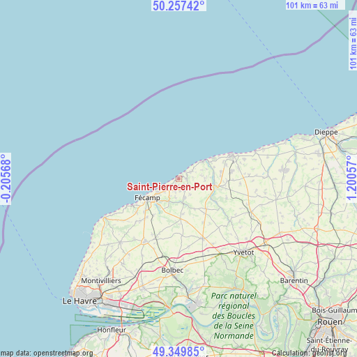
| Map corner | latitude | longitude |
|---|---|---|
| Upper-left | 50.25742°, | -0.20568° |
| Center: | 49.80576°, | 0.49744° |
| Lower-right: | 49.34985°, | 1.20057° |
| Map W x H: | 100.9×100.9 km | = 62.7×62.7mi |
| max Lat: | 51.07786° ⇑7.7% North |
| Saint-Pierre-en-Port: | 49.80576° |
| min Lat: | ⇓92.3% South 41.3874° |
| min Long | Saint-Pierre-en | max Long |
| -5.08615° | 0.49744° | 9.52242° |
| W 26.6%⇐ | ⇒73.4% E |
Elevation
Elevation of Saint-Pierre-en-Port is 91 m = 299 ft, and this is 102.7 m = 337 ft below average elevation for this country.
| Max E: |
2333 m = 7654 ft | 64.4% |
| Avg. | 193.7 m = 635 ft | |
| Saint-Pierre-en-Port | 91 m = 299 ft | |
Min E: |
-1 m = -3 ft | 35.6% |
See also: France elevation on elevation.city.
Geographical zone
Saint-Pierre-en-Port is located in North temperate zone (between Tropic of Cancer and the Arctic Circle). Distance of this North polar circle is 1863.3 km =1157.8 mi to North.| Distance of | km | miles | from Saint-Pierre-en-Port |
|---|---|---|---|
| North Pole | 4469.2 | 2777 | to North |
| Arctic Circle | 1863.3 | 1157.8 | to North |
| Tropic Cancer | 2932 | 1821.9 | to South |
| Equator | 5537.9 | 3441.1 | to South |


Nearby cities:
15 places around Saint-Pierre-en-Port: (largest is in red/bold)
• Angerville-la-Martel
4.9 km =3 mi,  175°
175°
• Bertheauville
9.4 km =5.8 mi,  127°
127°
• Cany-Barville
10.2 km =6.3 mi,  100°
100°
• Colleville
6.9 km =4.3 mi,  203°
203°
• Fécamp
10.3 km =6.4 mi,  238°
238°
• Grainville-la-Teinturière
12.1 km =7.5 mi,  122°
122°
• Ourville-en-Caux
11.5 km =7.1 mi,  138°
138°
• Saint-Martin-aux-Buneaux
4.7 km =2.9 mi,  63°
63°
• Sainte-Hélène-Bondeville
4.3 km =2.7 mi,  216°
216°
• Sassetot-le-Mauconduit
2.1 km =1.3 mi,  92°
92°
• Senneville-sur-Fécamp
7 km =4.3 mi, 237°
• Toussaint
9.2 km =5.7 mi,  214°
214°
• Valmont
7 km =4.3 mi,  170°
170°
• Vittefleur
10.2 km =6.3 mi,  80°
80°
• Életot
3.9 km =2.4 mi, 240°
Sources, notices
• [Note1] Compared only with cities in France existing in our database
• [Src1] Map data: © OpenStreetMap contributors (CC-BY-SA)
• [Src2] Other city data from geonames.org with taken over terms of usage.
• [Src3] Geographical zone / Annual Mean Temperature by Robert A. Rohde @ Wikipedia
