Écommoy geodata
Écommoy (Pays de la Loire) is a populated place; located in France in Europe/Paris (GMT+2) time zone. With population of 4,537 people, there are 2175 cities with bigger population in this country. Compared to other cities in France, 56.2% of cities are located further ↓South; 75.6% of cities are located further →East and 68.7% of cities have higher elevation than Écommoy. Note1
Administrative division(s):
- Level 1: Pays de la Loire
- Level 2: Sarthe
- Level 3: Arrondissement du Mans
- Level 4: Écommoy


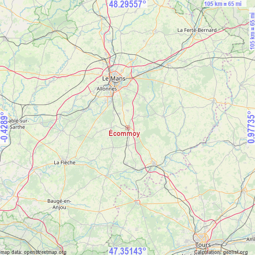
Écommoy GPS coordinates[2]
47° 49' 32.34" North, 0° 16' 27.192" East
| Map corner | latitude | longitude |
|---|---|---|
| Upper-left | 48.29557°, | -0.4289° |
| Center: | 47.82565°, | 0.27422° |
| Lower-right: | 47.35143°, | 0.97735° |
| Map W x H: | 105×105 km | = 65.2×65.2mi |
| max Lat: | 51.07786° ⇑43.8% North |
| Écommoy: | 47.82565° |
| min Lat: | ⇓56.2% South 41.3874° |
| min Long | Écommoy | max Long |
| -5.08615° | 0.27422° | 9.52242° |
| W 24.4%⇐ | ⇒75.6% E |
Elevation
Elevation of Écommoy is 81 m = 266 ft, and this is 112.7 m = 370 ft below average elevation for this country.
| Max E: |
2333 m = 7654 ft | 68.7% |
| Avg. | 193.7 m = 635 ft | |
| Écommoy | 81 m = 266 ft | |
Min E: |
-1 m = -3 ft | 31.3% |
See also: France elevation on elevation.city.
Geographical zone
Écommoy is located in North temperate zone (between Tropic of Cancer and the Arctic Circle). Distance of this North polar circle is 2083.5 km =1294.6 mi to North.| Distance of | km | miles | from Écommoy |
|---|---|---|---|
| North Pole | 4689.3 | 2913.8 | to North |
| Arctic Circle | 2083.5 | 1294.6 | to North |
| Tropic Cancer | 2711.8 | 1685 | to South |
| Equator | 5317.7 | 3304.3 | to South |


Nearby cities:
15 places around Écommoy: (largest is in red/bold)
• Brette-les-Pins
10.5 km =6.5 mi,  26°
26°
• Laigné-en-Belin
6.7 km =4.2 mi,  328°
328°
• Marigné-Laillé
5 km =3.1 mi,  100°
100°
• Mayet
7.3 km =4.5 mi,  179°
179°
• Moncé-en-Belin
9.5 km =5.9 mi,  323°
323°
• Mulsanne
9.7 km =6 mi,  349°
349°
• Pontvallain
10.3 km =6.4 mi,  216°
216°
• Requeil
9.7 km =6 mi,  241°
241°
• Saint-Biez-en-Belin
2.7 km =1.7 mi,  258°
258°
• Saint-Gervais-en-Belin
7.1 km =4.4 mi, 323°
• Saint-Mars-d’Outillé
6.6 km =4.1 mi,  41°
41°
• Saint-Ouen-en-Belin
4.9 km =3 mi,  279°
279°
• Teloché
7 km =4.3 mi,  357°
357°
• Verneil-le-Chétif
10.4 km =6.5 mi,  171°
171°
• Yvré-le-Pôlin
8.8 km =5.5 mi,  267°
267°
Sources, notices
• [Note1] Compared only with cities in France existing in our database
• [Src1] Map data: © OpenStreetMap contributors (CC-BY-SA)
• [Src2] Other city data from geonames.org with taken over terms of usage.
• [Src3] Geographical zone / Annual Mean Temperature by Robert A. Rohde @ Wikipedia
