Verneil-le-Chétif geodata
Verneil-le-Chétif (Pays de la Loire) is a populated place; located in France in Europe/Paris (GMT+2) time zone. With population of 662 people, there are 12351 cities with bigger population in this country. Compared to other cities in France, 54.7% of cities are located further ↓South; 75.4% of cities are located further →East and 64.4% of cities have higher elevation than Verneil-le-Chétif. Note1
Administrative division(s):
- Level 1: Pays de la Loire
- Level 2: Sarthe
- Level 3: Arrondissement de La Flèche
- Level 4: Verneil-le-Chétif


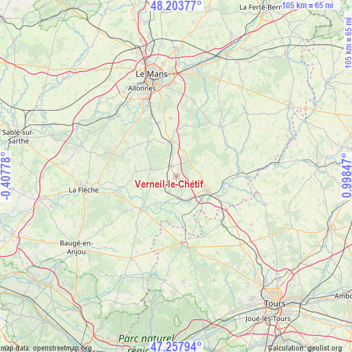
Verneil-le-Chétif GPS coordinates[2]
47° 43' 58.8" North, 0° 17' 43.224" East
| Map corner | latitude | longitude |
|---|---|---|
| Upper-left | 48.20377°, | -0.40778° |
| Center: | 47.733°, | 0.29534° |
| Lower-right: | 47.25794°, | 0.99847° |
| Map W x H: | 105.2×105.2 km | = 65.4×65.4mi |
| max Lat: | 51.07786° ⇑45.3% North |
| Verneil-le-Chétif: | 47.733° |
| min Lat: | ⇓54.7% South 41.3874° |
| min Long | Verneil-le-Ché | max Long |
| -5.08615° | 0.29534° | 9.52242° |
| W 24.6%⇐ | ⇒75.4% E |
Elevation
Elevation of Verneil-le-Chétif is 91 m = 299 ft, and this is 102.7 m = 337 ft below average elevation for this country.
| Max E: |
2333 m = 7654 ft | 64.4% |
| Avg. | 193.7 m = 635 ft | |
| Verneil-le-Chétif | 91 m = 299 ft | |
Min E: |
-1 m = -3 ft | 35.6% |
See also: France elevation on elevation.city.
Geographical zone
Verneil-le-Chétif is located in North temperate zone (between Tropic of Cancer and the Arctic Circle). Distance of this North polar circle is 2093.8 km =1301 mi to North.| Distance of | km | miles | from Verneil-le-Chétif |
|---|---|---|---|
| North Pole | 4699.6 | 2920.2 | to North |
| Arctic Circle | 2093.8 | 1301 | to North |
| Tropic Cancer | 2701.5 | 1678.6 | to South |
| Equator | 5307.4 | 3297.9 | to South |


Nearby cities:
15 places around Verneil-le-Chétif: (largest is in red/bold)
• Aubigné-Racan
5.1 km =3.2 mi,  203°
203°
• Château-du-Loir
10.1 km =6.3 mi,  114°
114°
• Coulongé
8.5 km =5.3 mi,  235°
235°
• Flée
11.8 km =7.3 mi,  89°
89°
• Jupilles
10.9 km =6.8 mi,  53°
53°
• Luceau
8 km =5 mi, 107°
• Mansigné
12.2 km =7.6 mi,  277°
277°
• Marigné-Laillé
10 km =6.2 mi,  19°
19°
• Mayet
3.3 km =2.1 mi,  332°
332°
• Montabon
8.7 km =5.4 mi,  129°
129°
• Pontvallain
8 km =5 mi, 284°
• Requeil
11.5 km =7.1 mi,  299°
299°
• Saint-Biez-en-Belin
10.6 km =6.6 mi,  336°
336°
• Vaas
7.3 km =4.5 mi,  167°
167°
• Écommoy
10.4 km =6.5 mi,  351°
351°
Sources, notices
• [Note1] Compared only with cities in France existing in our database
• [Src1] Map data: © OpenStreetMap contributors (CC-BY-SA)
• [Src2] Other city data from geonames.org with taken over terms of usage.
• [Src3] Geographical zone / Annual Mean Temperature by Robert A. Rohde @ Wikipedia
