Dunkerque geodata
Dunkerque (Hauts-de-France) is a seat of a third-order administrative division; located in France in Europe/Paris (GMT+2) time zone. With population of 71,287 people, there are 65 cities with bigger population in this country. Compared to other cities in France, 100% of cities are located further ↓South; 51.4% of cities are located further →East and 97.4% of cities have higher elevation than Dunkerque. Note1
Administrative division(s):
- Level 1: Hauts-de-France
- Level 2: Nord
- Level 3: Arrondissement de Dunkerque
- Level 4: Dunkerque


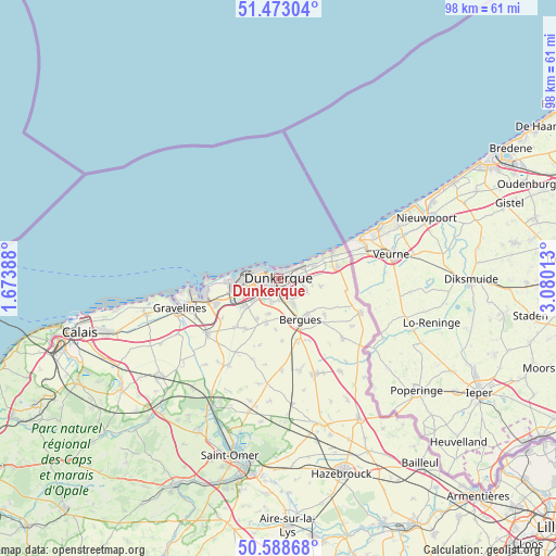
Dunkerque GPS coordinates[2]
51° 1' 58.692" North, 2° 22' 37.2" East
| Map corner | latitude | longitude |
|---|---|---|
| Upper-left | 51.47304°, | 1.67388° |
| Center: | 51.03297°, | 2.377° |
| Lower-right: | 50.58868°, | 3.08013° |
| Map W x H: | 98.3×98.3 km | = 61.1×61.1mi |
| max Lat: | 51.07786° ⇑0% North |
| Dunkerque: | 51.03297° |
| min Lat: | ⇓100% South 41.3874° |
| min Long | Dunkerque | max Long |
| -5.08615° | 2.377° | 9.52242° |
| W 48.6%⇐ | ⇒51.4% E |
Elevation
Elevation of Dunkerque is 10 m = 33 ft, and this is 183.7 m = 603 ft below average elevation for this country.
| Max E: |
2333 m = 7654 ft | 97.4% |
| Avg. | 193.7 m = 635 ft | |
| Dunkerque | 10 m = 33 ft | |
Min E: |
-1 m = -3 ft | 2.6% |
See also: Dunkerque elevation on elevation.city.
Geographical zone
Dunkerque is located in North temperate zone (between Tropic of Cancer and the Arctic Circle). Distance of this North polar circle is 1726.8 km =1073 mi to North.| Distance of | km | miles | from Dunkerque |
|---|---|---|---|
| North Pole | 4332.7 | 2692.2 | to North |
| Arctic Circle | 1726.8 | 1073 | to North |
| Tropic Cancer | 3068.4 | 1906.6 | to South |
| Equator | 5674.3 | 3525.8 | to South |


Nearby cities:
15 places around Dunkerque: (largest is in red/bold)
• Armbouts-Cappel
6.5 km =4 mi,  194°
194°
• Bergues
8.1 km =5 mi,  151°
151°
• Bierne
8.2 km =5.1 mi,  163°
163°
• Cappelle-la-Grande
3.9 km =2.4 mi,  199°
199°
• Coudekerque-Branche
1.6 km =1 mi,  134°
134°
• Coudekerque-Village
4.6 km =2.9 mi,  142°
142°
• Fort-Mardyck
4.9 km =3 mi,  264°
264°
• Grande-Synthe
5.7 km =3.5 mi,  250°
250°
• Hoymille
8.4 km =5.2 mi, 144°
• Leffrinckoucke
6.1 km =3.8 mi,  88°
88°
• Saint-Pol-sur-Mer
2.6 km =1.6 mi,  265°
265°
• Spycker
8.1 km =5 mi,  208°
208°
• Téteghem
5 km =3.1 mi,  108°
108°
• Uxem
7.6 km =4.7 mi,  99°
99°
• Zuydcoote
8.7 km =5.4 mi,  69°
69°
Sources, notices
• [Note1] Compared only with cities in France existing in our database
• [Src1] Map data: © OpenStreetMap contributors (CC-BY-SA)
• [Src2] Other city data from geonames.org with taken over terms of usage.
• [Src3] Geographical zone / Annual Mean Temperature by Robert A. Rohde @ Wikipedia
