Zuydcoote geodata
Zuydcoote (Hauts-de-France) is a populated place; located in France in Europe/Paris (GMT+2) time zone. With population of 1,660 people, there are 5636 cities with bigger population in this country. Compared to other cities in France, 100% of cities are located further ↓South; 50.5% of cities are located further ←West and 99.8% of cities have higher elevation than Zuydcoote. Note1
Administrative division(s):
- Level 1: Hauts-de-France
- Level 2: Nord
- Level 3: Arrondissement de Dunkerque
- Level 4: Zuydcoote


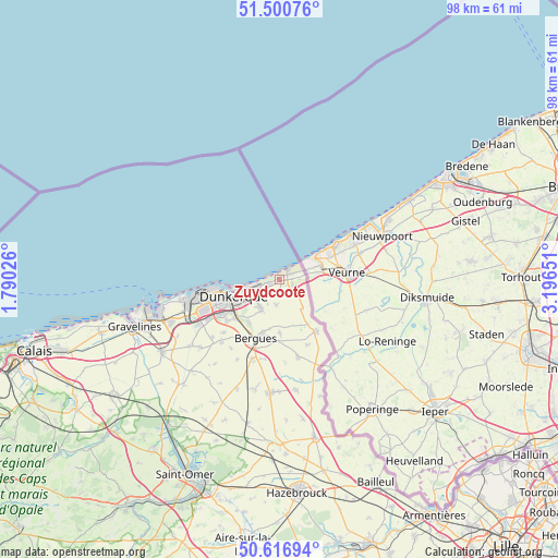
Zuydcoote GPS coordinates[2]
51° 3' 39.456" North, 2° 29' 36.168" East
| Map corner | latitude | longitude |
|---|---|---|
| Upper-left | 51.50076°, | 1.79026° |
| Center: | 51.06096°, | 2.49338° |
| Lower-right: | 50.61694°, | 3.19651° |
| Map W x H: | 98.3×98.3 km | = 61.1×61.1mi |
| max Lat: | 51.07786° ⇑0% North |
| Zuydcoote: | 51.06096° |
| min Lat: | ⇓100% South 41.3874° |
| min Long | Zuydcoote | max Long |
| -5.08615° | 2.49338° | 9.52242° |
| W 50.5%⇐ | ⇒49.5% E |
Elevation
Elevation of Zuydcoote is 3 m = 10 ft, and this is 190.7 m = 626 ft below average elevation for this country.
| Max E: |
2333 m = 7654 ft | 99.8% |
| Avg. | 193.7 m = 635 ft | |
| Zuydcoote | 3 m = 10 ft | |
Min E: |
-1 m = -3 ft | 0.2% |
See also: France elevation on elevation.city.
Geographical zone
Zuydcoote is located in North temperate zone (between Tropic of Cancer and the Arctic Circle). Distance of this North polar circle is 1723.7 km =1071.1 mi to North.| Distance of | km | miles | from Zuydcoote |
|---|---|---|---|
| North Pole | 4329.6 | 2690.3 | to North |
| Arctic Circle | 1723.7 | 1071.1 | to North |
| Tropic Cancer | 3071.5 | 1908.5 | to South |
| Equator | 5677.4 | 3527.8 | to South |


Nearby cities:
15 places around Zuydcoote: (largest is in red/bold)
• Bergues
11.1 km =6.9 mi,  202°
202°
• Bray-Dunes
2.5 km =1.6 mi,  40°
40°
• Cappelle-la-Grande
11.6 km =7.2 mi,  234°
234°
• Coudekerque-Branche
8.2 km =5.1 mi,  238°
238°
• Coudekerque-Village
8.6 km =5.3 mi,  218°
218°
• Dunkerque
8.7 km =5.4 mi,  249°
249°
• Ghyvelde
2.5 km =1.6 mi,  111°
111°
• Hondschoote
11.2 km =7 mi,  145°
145°
• Hoymille
10.4 km =6.5 mi, 197°
• Leffrinckoucke
3.6 km =2.2 mi,  214°
214°
• Les Moëres
6.5 km =4 mi,  143°
143°
• Saint-Pol-sur-Mer
11.2 km =7 mi, 252°
• Téteghem
5.8 km =3.6 mi, 215°
• Uxem
4.4 km =2.7 mi,  188°
188°
• Warhem
9.5 km =5.9 mi,  180°
180°
Sources, notices
• [Note1] Compared only with cities in France existing in our database
• [Src1] Map data: © OpenStreetMap contributors (CC-BY-SA)
• [Src2] Other city data from geonames.org with taken over terms of usage.
• [Src3] Geographical zone / Annual Mean Temperature by Robert A. Rohde @ Wikipedia
